The coming food, water crises – Richard Mills
2026.04.25
Tariffs, the Iran war and a historic drought are negatively impacting US farmers and food prices. World food systems are being pushed to the brink due to extreme heat — on land and in the oceans.
With limited conflicts and outright wars now common, combatants see that weaponizing shipping choke points is an effective means of exerting leverage on the enemy. Just-in-Time supply chains, which depend on freedom of navigation, are under threat — especially food, which is highly vulnerable to spoilage.
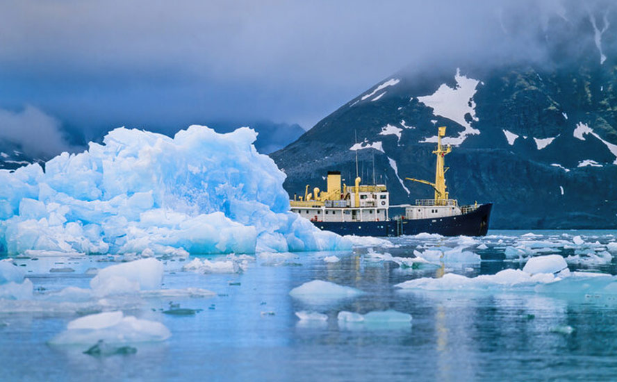
As the planet warms, glaciers are shrinking, affecting freshwater availability. Less winter precipitation is lowering snowpacks, which provide runoff that fills reservoirs. The outlook for the Colorado River, and Lake Powell in particular, continues to worsen. Less soil moisture in agricultural regions means that natural water sources like freshet, rain and groundwater must be replaced by irrigation, further straining shared water supplies. Dry forests create the perfect conditions for wildfires, human- or lightning-caused.
Cascading events
American farmers were already dealing with more expensive fertilizer and diesel fuel due to the closure of the Strait of Hormuz, and other higher input costs like livestock feed and labor because of the Trump administration’s tariffs and a crackdown on illegal immigrants — many of whom are part of the country’s shadow agricultural labor pool.
Now that their crops are planted, farmers can add a historic drought and scarce water supplies to their worries. Fortune magazine sums up the problem:
An overlapping series of headwinds—ranging from climate to economics and geopolitics—have made farming in the U.S. an exceptionally brutal profession in recent months. The headaches started last year when the Trump administration’s sweeping tariff regime warped the country’s trade policy, raising input costs for farmers and crowding out international buyers. This year, the war in the Middle East has caused the global fuel and fertilizer trade to sputter, further squeezing farmers’ margins.
According to the NOAA (National Oceanic and Atmospheric Administration), 61% of the continental US is currently under moderate to exceptional drought conditions, including 97% of the Southeast and two-thirds of the Western US. The upshot for farmers is reduced yields and potentially failed harvests. If nothing happens to alleviate the situation, it likely means higher food prices for the rest of the year.
“What’s unique about the current moment is that you have this perfect storm of factors,” David Ortega, an agricultural economist at Michigan State University, told Fortune.
March was the warmest month on record in the States due to an unseasonal heat wave, spreading drought over huge portions of the country’s arable land much earlier than normal. Hard-hit areas include the Central Plains and parts of the South, all along the Cotton Belt.
Fortune reports staple crops in the South and Midwest are under drought, including nearly 70% of winter wheat production, 29% of soybeans and 26% of corn. A lack of moisture this early in the season can stunt plant growth, prevent pollination and lower yields later on.
Compounding the problem is the probable emergence of El Nino, a climate pattern characterized by the warming of ocean surface temperatures in the central and eastern tropical Pacific Ocean.
During an El Nino, the northern US/Canada often see warmer, drier winters, the southern US can experience wetter conditions, and countries like Australia and Indonesia may face droughts.
The planet was last in El Nino between May 2023 and March 2024. The winter of 2024 saw record-breaking warmth globally, with Canada experiencing its hottest winter on record and Europe its warmest February and second-warmest winter. 2024 was the hottest year on record globally, corresponding with an El Nino year. 2023 was the worst year for forest fires in Canada.
A lingering El Nino is likely to mean a drying trend in places accustomed to rainfall and vice versa, with implications for agriculture. We are currently in the process of transitioning from La Nina to El Nino.
An agricultural economist quoted by Fortune said farmers are currently feeling higher diesel costs, but as they get into late summer and early fall, they will start feeling the impact of more expensive fertilizer. A recent survey of 5,700 farmers found 70% can’t afford the fertilizer they need for the season.
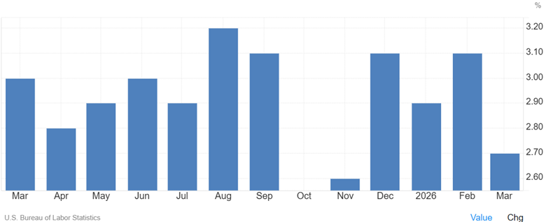
The cascading series of events will eventually show up in higher food prices. The Department of Agriculture’s latest price forecast published in March projected food prices will rise 3.6% in 2026, compared to February’s prediction of 3.1%. If crops start failing, Fortune notes reduced yields could lead to higher prices for livestock feed, which will mean even more expensive meat and dairy products.
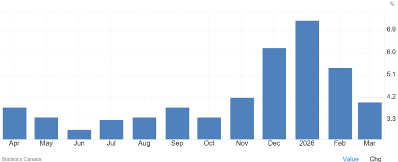
In Canada, the foot inflation outlier is fresh vegetables. CBC News reported this week that they cost 7.8% more year over year in March —the largest increase since March 2023.
Of all the fresh vegetables, cucumbers are seeing the worst inflation, with prices rising 28.4% over the past year due to production shortages.
In the colder months, Canada imports much of its cucumbers from Mexico and the US, where supply has been affected by poor weather and disease, the CBC explained.
Extreme heat’s effects on agriculture
Heat and drought, of course, isn’t confined to the US. The United Nations, via The Guardian, is warning that extreme heat is threatening the world’s food systems, with farmers unable to work outside, livestock experiencing stress, and crop yields falling, putting the livelihoods of more than a billion people in peril.
The newspaper quotes a joint report by the Food and Agricultural Organization (FAO) and the World Meteorological Association (WMO) that states food supply is some areas is being “pushed to the brink” by increasingly common and severe heat waves on land and at sea. Among its findings:
- Farmers could find it impossible to work safely for as many as 250 days of the year – more than two-thirds of the time – in already hot regions including much of India and south Asia, tropical sub-Saharan Africa and swathes of Central and South America.
- Livestock are already experiencing an increase in mortality rates, as heat stress begins for common species at about 25C.
- Yields begin to decline at temperatures above 30C for most agricultural crops.
- Ocean heatwaves are also killing fish, as heat reduces the level of dissolved oxygen in the water, leading to mass decline in populations.
- Modern industrialised food systems rely on a narrow range of staple crops, and highly specialized systems that are dependent on inputs such as fertilizer. That makes them highly vulnerable and less able to cope with shocks, such as extreme heat.
Gulf’s food, water supplies at risk
Media coverage of the Iran war has been sparse on how it is affecting the region’s food and water supplies. This is surprising, given that Gulf states are around 90% reliant on imports for food. Over 70% of foodstuffs are imported through the Strait of Hormuz, which remains closed as the United States and Iran try to hash out a peace plan.
More important for food imports though is the US navy’s blockade of Iranian ports. An AI Overview states that the blockade, initiated around April 13, has created significant disruption to maritime trade, affecting nearly a million tons of grain and oilseeds.
While Iran claims domestic production (85%) and alternative routes have kept food security stable, reports indicate rising prices, potential shortages, and reduced vessel traffic. Prices for staples like rice have already seen massive increases, with fears of further inflation.
Most major Gulf ports are located where incoming ships would have to pass through the Hormuz Strait. Early in the war, Iran attacked Dubai’s Jebel Ali, the region’s largest container port.
The UAE reportedly has strategic reserves of vital goods to last it four to six months. After the 2008 financial crisis, soaring food prices prompted Gulf nations to shift toward import-dependent policies.
According to Reuters, Apart from investing abroad to secure access to major food production bases, Gulf states have also been constructing modern silos capable of storing hundreds of thousands of tons of strategic grains in the past two decades. These silos offer a buffer for staples that can be stored for months like wheat, rice and edible oils.
Regarding water, the vast majority comes from desalination plants, over 400 of which line the Persian Gulf. According to Middle East Eye, the Gulf accounts for 60% of global desalination capacity. In the UAE and Kuwait, 90% of drinking water comes from desalination plants; in Oman 86% and in Saudi Arabia 70%.
One Gulf analyst who works on the intersection of geopolitics and food security in the region told MEE that some have built up strategic stocks, but for small states like Qatar and Bahrain, these could be depleted in days if their desalination plants were destroyed.
“You can’t imagine how water-intensive these economies are. Especially as we are entering the spring and summer. They don’t have a plan if those facilities are targeted,” the analyst said, speaking on condition of anonymity.
In fact, desalination plant have been hit, despite a prohibition by the Geneva Convention due to their necessity for civilian survival.
According to the New York Times, facilities have been struck in Iran, Bahrain and Kuwait, with Iranian officials reporting a US strike on a plant at Queshm Island, and Bahrain reporting an Iranian drone attack.
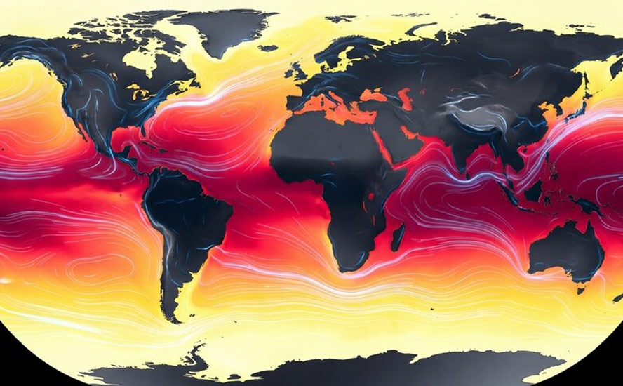
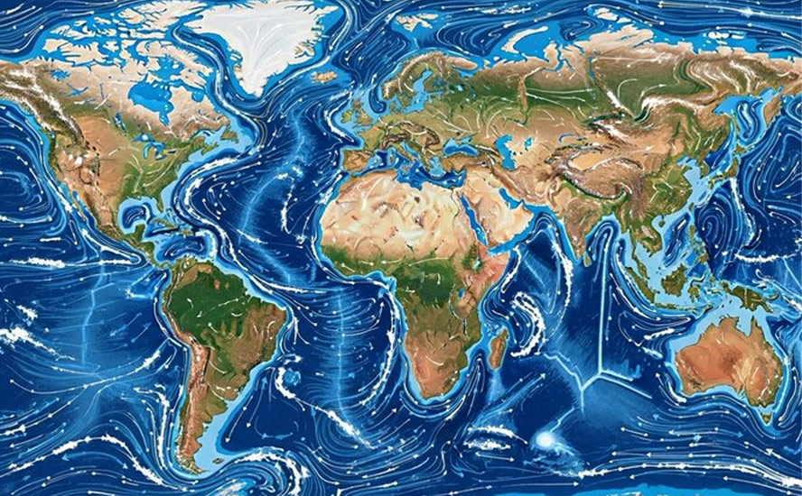
Marine heat wave/ Super El Nino
Returning to global warming, scientists are warning of an extremely large marine heat wave that could worsen heat and humidity in the Western US this summer and also boost the risk of Pacific hurricanes and wildfires in the region.
The Washington Post reports the unusual ocean anomaly — which stretches 5,000 miles across the Pacific Ocean from Micronesia to California — has warmed waters from 6 to 8 degrees above average.
The ocean hot spot is linked to the formation of El Nino. By late summer it could cover the entire Pacific coast of North America. Climate scientists say the marine heat wave is being driven by the Pacific Meridional Mode (PMM), which is marked by warmer than average seas that stretch southwest to northwest across the Pacific for thousands of miles.
CNN reported the marine heat wave is most impacting sea birds, with many birds being brought into rehabilitation facilities or washing up dead. The main cause of death is starvation, because cold-water fish are moving northward and to deeper depths, making it difficult for seabirds to find them.
The marine heat wave is an extension of a trend. According to Earth.com, ocean temperatures reached all-time highs in 2025:
Using multiple independent datasets and contributions from more than 50 scientists, the assessment estimates the ocean gained about 23 zettajoules of heat in 2025 – an amount of energy comparable to decades of global human energy use…
The observations all pointed the same way: 2025 hit the highest ocean heat content level on record. And it’s part of a streak – ocean has set a new record high in each of the last nine years.
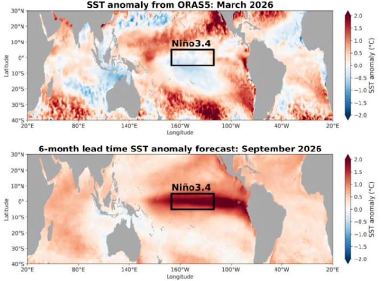
We’ve discussed the current marine heat wave and the coming El Nino climate pattern. But what if El Nino, when it arrives, is stronger than previous incarnations? CNBC reports there is a one-in-three chance of a planet-warming El Nino forming in October to December, with a “Super El Nino” posing new risks to global food costs.
To be classified a Super El Nino, sea surface temperatures in the eastern Pacific would need to rise at least 2 degrees Celsius above normal.
If this were to occur, global temperatures would almost certainly spike into record territory.
A Super El Nino cometh: Get ready for drought, heat, fires — Richard Mills
Such an event is driven by powerful westerly wind bursts and a massive ocean Kelvin wave currently surfacing in the eastern Pacific, claims one source:
Such an intense warming of the tropical Pacific can fundamentally alter the global jet stream and trigger a domino effect that extends across North America, Europe, and the rest of the globe.
How likely is a Super El Nino and how accurate are current predictions? According to Phys.org, researchers from the University of Hawaii have published a study in Geophysical Research Letters showing that they can skillfully predict El Nino and La Nina 15 months ahead of time.
A team from the UH Mānoa School of Ocean and Earth Science and Technology (SOEST) developed the Wyrtki-CSLIM computer model to predict ENSO, an acronym for El Nino’s full name, the El Nino-Southern Oscillation. The model currently predicts the development of a strong El Nino more than 2C warmer than normal over the equatorial eastern Pacific toward the end of the year.
The Independent details the profound effects a Super El Nino would have on US and global weather:
- A strong El Niño generally makes the whole world warmer, as all that heat wafting up from the ocean gets spread far beyond the tropics. That could lead to a hotter-than-usual summer in the western U.S., potentially worsening the wildfire season in California and Oregon. In the past, it has also often meant a cooler summer in the U.S. South.
- Conversely, Western and Southern winters could be wetter than normal, leading to more snowfall in the mountains and perhaps some relief for the ongoing droughts in many states.
- As of early 2026, Lake Mead’s water level is approximately 1,062 feet above sea level, placing the reservoir at roughly 33% of capacity. The lake is expected to experience significant drops towards 2027, potentially reaching around 1,032 feet, which would be less than the historic low of 1,041 feet set in 2022. (AI Overview)
- The Midwest might see drier weather, while the Pacific Northwest is likely to be unusually hot.
- “El Niño patterns could bring more rain than normal to the Colorado Basin,” said AccuWeather meteorologist Chat Merrill. “The early start to the El Niño can lead to an increase in moisture from the southern Plains to East Coast during summer and fall.”
- Extreme weather is more likely overall, with intense heat in tropical countries and potentially widespread droughts around the world.
Regarding the food supply, CNBC says the prospect of a Super El Nino comes at a time when many have raised the alarm over surging fuel and fertilizer costs due to the Iran war. One analyst told CNBC that an El Nino event could put upward pressure on cocoa, food oils, rice and sugar. Chris Jaccarini with the Energy and Climate Intelligence Unit cited risks for other products linked to the tropics, such as bananas, tea, coffee, chocolate and soy-fed meat.
Apart from raising the prices of certain foods, a Super El Nino would contribute to food insecurity, which is cited as a growing problem in an analysis published last month by the UN World Food Program.
According to CNBC, The WFP estimates that the number of people facing acute hunger could jump by 45 million if the Iran war persists beyond June and oil prices stay above $100 per barrel. This prediction would add to the 318 million people across the globe who are already food insecure…
Dawid Heyl, a co-portfolio manager for the global natural resources strategy at Ninety One, said the prospect of an El Niño event poses a risk to global food production, but the extent of this risk depends on when the climate phenomenon develops, how extreme it is and how long it lasts…
The likes of India, Australia, Brazil and Argentina were all cited as countries that could be significantly exposed to El Niño, Heyl said, albeit for different reasons.
The European Union, meanwhile, said earlier this month that an El Niño event later this year threatens northwestern Ethiopia, South Sudan and Sudan with dry conditions, “posing a significant risk to the main agricultural season.”
Droughts
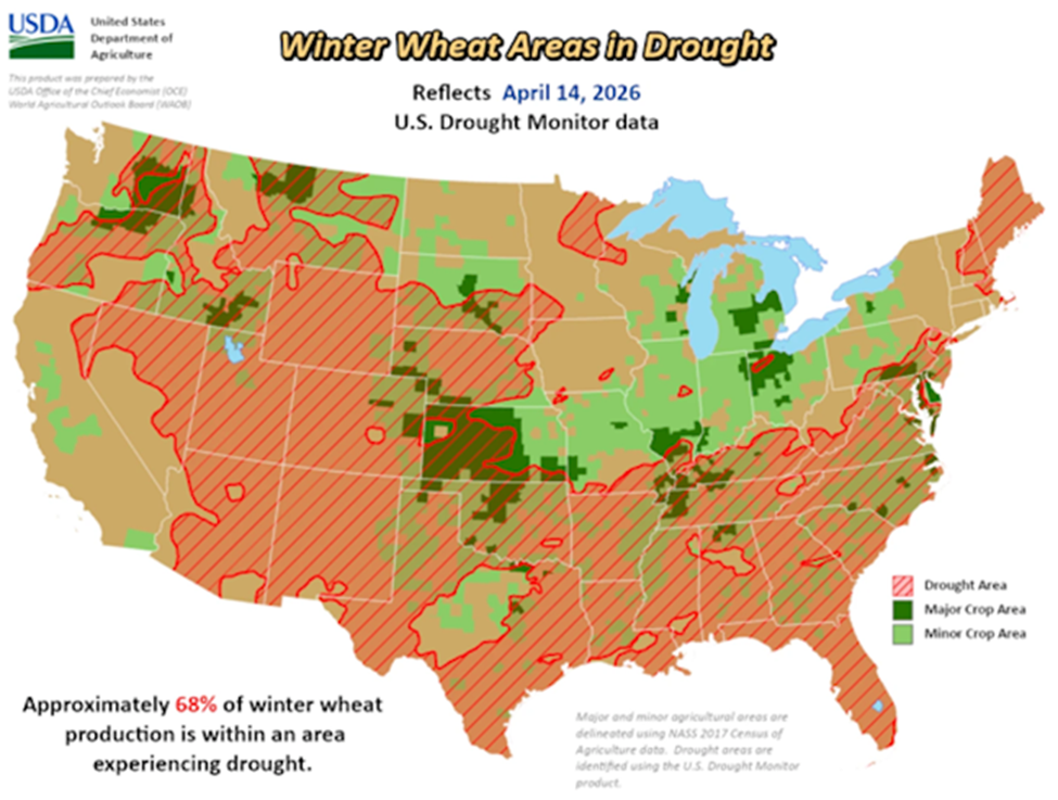
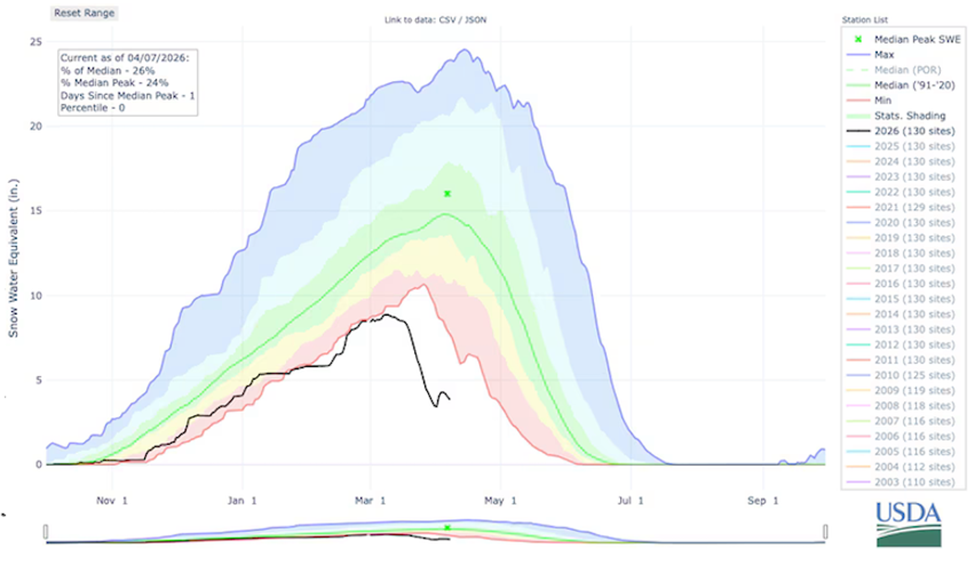
We’ve already touched on the US drought situation. Let’s go deeper. According to AgWeb Farm Journal, the April 14 US Drought Monitor shows 75% of the US is dealing with some level of drought or dryness. As stated above, 61% of the continental US is currently under moderate to exceptional drought conditions. This is the highest level since November 2022. And it’s only April.
See the current April 23 Drought Monitor below.
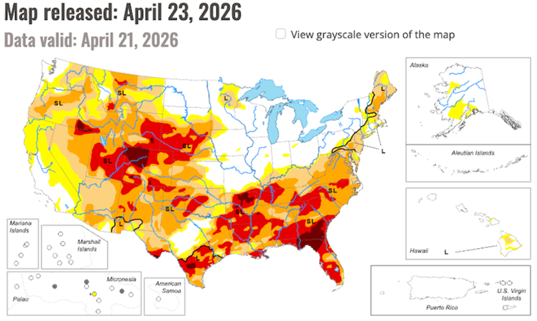

Among AgWeb’s findings, referring to the April 14 Drought Monitor:
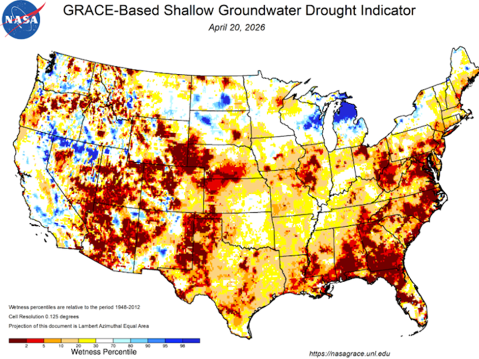
- The drought and dryness picture is even clearer in the latest root zone moisture map from NASA, which shows the amount of moisture in the top 3 feet of soil versus a historical average. The soil in parts of the eastern Corn Belt, the Southeast and into the western Plains is parched and in need of a rain.
- The Drought Monitor shows an expanding footprint. “The Drought Monitor has been roughly 80% now for over a month,” says Eric Snodgrass, senior science fellow, Nutrien Ag Solutions. In the Southeast, he says Arkansas is showing a 15-inch deficit since last October. “The Southeast is enduring one of the driest springs it has had historically going back to the late 1800s. The drought there is a rough picture. The high plains are absolutely bone dry. Big dust storms. Nebraska’s really taking a beating. They’re pre-irrigating the crop.”
- Winter wheat acres could be abandoned. In winter wheat country, 68% of the acres are experiencing drought. “I think there’s going to be a lot of lost acres. They’re waiting on rain that now if it comes, it’s almost too late,” Snodgrass says. “I was talking to a grower on the tip of the Red River, and he said he’s already had the insurance adjuster out and was looking at 1 bu. to 19 bu. yields. The crop is gone.”
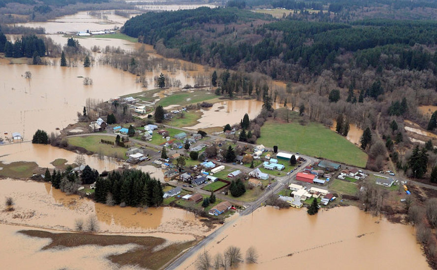
The drought picture in Canada is considerably better, although there are concerning pockets of dryness. As of March 31, 39% of the country was classified as Abnormally Dry (D0) or in Moderate (D1) to Severe Drought (D2), including 32% of the country’s agricultural landscape.

A national overview says that while much of Canada received normal to well above normal precipitation in March, well below normal precipitation for that month occurred throughout much of the territories and northern Manitoba. Regional monthly precipitation deficits were recorded in the southern Interior of British Columbia, southern Alberta, and central New Brunswick. Above normal temperatures and below normal precipitation in southern Alberta and southwestern Saskatchewan continued to reduce soil moisture and increase the extent and severity of drought. Severe Drought (D2) remained in portions of southern Quebec, southern New Brunswick, and portions of Prince Edward Island.
Agriculture Canada via CBC News reports BC’s Southern Interior, including the southern portions of the Thompson-Okanagan and Kootenays, are in a drought after having received less than 40% of normal precipitation over the winter.
Low snowpack
Drought fears in BC’s Okanagan region are being activated by a historically low snowpack. The media has widely reported on data from the B.C. River Forecast Centre showing the snowpack at just 58% of normal — a record low since tracking began in 1980. The previous record was 67% in 1981.
Jonathan Boyd, a hydrologist at the center, was quoted saying that snowpack alone doesn’t necessarily guarantee drought. He pointed to the overarching weather conditions for the spring and summer as more indicative of whether drought does or doesn’t occur.
“With spring’s potential to bring heavy rainfall, there is still a chance Mother Nature could help avert a drought disaster,” Global News opined on April 10.
CBC News said the even lower snowpack on Vancouver Island — 44% of normal as of April 1 — is likely to stress salmon populations already dealing with the impacts of habitat degrading, overfishing and warmer waters.
Scientists say that lower snowpack levels mean that accumulated snow will melt quickly this spring — leading to lower water levels and drying pools when adult salmon try to make their way back up rivers in the fall from their spawning grounds…
Tom Balfour, a habitat biologist with the Redd Fish Restoration Society on the west coast of Vancouver Island, says that some pools where juvenile salmon gather in the summer could see die-offs on a scale large enough to impact larger salmon populations.
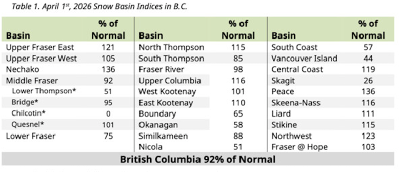
When examining the drought situation in BC, it’s important to recognize that provincially, the average snowpack is 92%, which is better than the 79% average at the same time last year.
The latest provincial bulletin showing a 92% average “masks a strong regional divide”, with some areas, including the Okanagan (58%), Vancouver Island (44%), Skagit (26%), Chilcotin (0%), Boundary (65%) and Nicola (51%) measuring much lower amounts.
“These regions with low snowpack are more susceptible to drought conditions heading into the spring and summer, particularly if warm and dry weather persists through the April to June period,” the river forecast centre warned.
Areas across northern and eastern BC, including the Skeena-Nass, Stikine, Peace, Upper Columbia and East Kootenay regions, along with the central coast, meanwhile recorded snowpack levels ranging from 110 to 136% of normal, said the bulletin via The Times Colonist.
The bulletin provides some insight into temperatures and precipitation this spring, saying seasonal outlooks from Environment Canada point to an increased likelihood of above-normal temperatures across B.C. through to June, with the strongest signals in southern and central areas.
Parts of northwestern B.C. show a weaker signal, closer to normal, it says.
Fires
2023 was the worst year for forest fires in Canada, corresponding with the first year of a two-year El Nino. CBC News reported more than 15 million hectares were destroyed by fire across the country, doubling the previous record, 7.6 million ha in 1989.
Are weather conditions setting up for a repeat of another disastrous wildfire season in 2026? While no-one can predict this early how the fire season will play out, there are some indicators that can help describe broad fire risks.
Mike Flanagan, a professor of wildland fire at Thompson Rivers University in Kamloops, BC, sees some cause for concern heading into this season. As reported by Canadian Press (CP):
Parts of Canada emerged from winter under abnormally dry or drought conditions, including historic wildfire hot spots in British Columbia’s southern interior, northern Manitoba and eastern Northwest Territories.
Long-range forecasts suggest much of Canada could be hotter than normal over the coming months. And El Niño, the warming phase of a recurring climate pattern tied to shifting waters in the Pacific Ocean, is expected to take hold this summer.
On the other hand, Richard Carr, a wildfire research analyst with Natural Resources Canada in Edmonton, said “We’re not really seeing too many signs of unusual activity through April.”
Exceptions include southern BC into southern Alberta and southwestern Saskatchewan, drought-stricken New Brunswick, and areas around Hudson Bay and eastern Northwest Territories where there was lower than normal snowfall.
CP notes we are heading into uncharted territory this wildfire season, coming off three consecutive severe fire years.
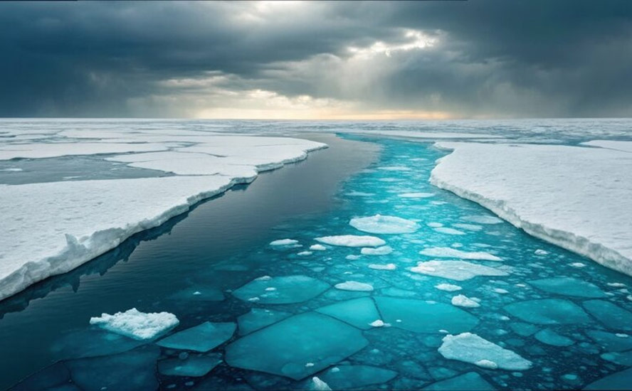
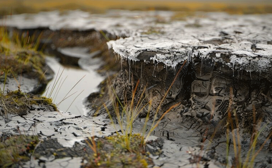
Water shortages
About 70% of the world’s fresh water is locked up in glaciers, with the remaining 30% stored underground as groundwater. Less than 1% is found in lakes, rivers and swamps.
2025 was among the worst years on record for global ice loss. Findings from a scientific study reveal that glaciers worldwide lost an estimated 408 gigatonnes of ice in 2025, marking the sixth most negative year since records began in 1975. The past decade has seen a dramatic acceleration in ice loss, with annual losses nearly four times higher than those observed in the late 20th century. (Phys.org)
The accelerating trend, of course, is driven by rising temperatures.
“These changes are not only reshaping mountain landscapes but are also contributing significantly to global sea-level rise and affecting water resources for millions of people,” said study co-author Dr. Levan Tielidze, from the Monash School of Earth, Atmosphere and Environment, and Securing Antarctica’s Environmental Future (SAEF).
The study shows that glacier mass loss has accelerated from less than 100 gigatonnes per year in the late 20th century to around 390 gigatonnes per year over the past decade.
In 2025, all 19 major glacier regions across the globe experienced net mass loss for the fourth consecutive year, with the largest regional losses recorded in areas including Western North America and Central Europe.
Over the longer term, glaciers have lost nearly 10,000 gigatonnes of ice since 1975, with almost 80% of that loss occurring since 2000…
The authors warn that continued high rates of ice loss could lead to the disappearance of many glaciers within decades, with cascading impacts on sea level, ecosystems and freshwater availability.
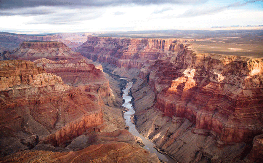
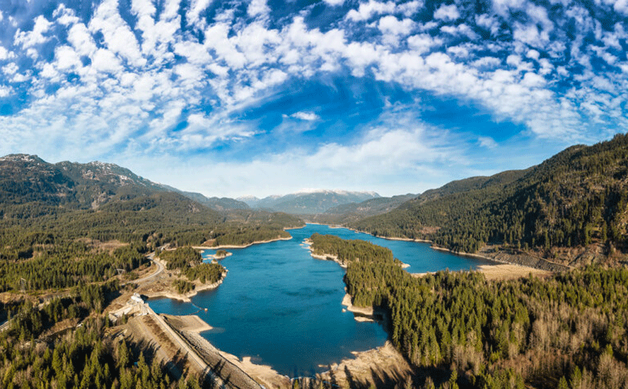
In North America, the canary in the coal mine for water loss is the Colorado River and its dams that hold back water in major reservoirs.
According to WyoFile, the outlook for the Colorado River, and Lake Powell in particular, continues to worsen due to an historically warm winter and dismal snowpack.
Projections show that Lake Powell on the Utah-Arizona border could drop low enough this year that it stops producing hydroelectric power at the Glen Canyon Dam. If it drops even lower, the dam is in danger of structural failure.
Officials say an official drawdown at Flaming Gorge, a reservoir upstream on the Green River in Wyoming and Utah, is imminent. That would release 1 million acre-feet, more than a quarter of its 3.8 million acre-feet storage capacity, rendering boat ramps inoperable.
The water situation is crashing so rapidly that authorities can’t confidently track the extent of it.
“Even though these projections are painting an incredibly dire picture for us, we need to be mindful that runoff might even be worse than what’s being projected,” Wyoming Senior Assistant Attorney General Chris Brown said on April 10, adding that dry soil throughout the region is a wildcard in water calculations. “It’s bad. It’s incredibly bad what we’re seeing in the Upper [Colorado River] Basin right now.”
There is also concern that after extra releases this year, it will take time to replenish Flaming Gorge. If the winter of 2027 is a repeat of 2026, Lake Powell could lose its fail-safe mechanism. Flaming Gorge was built to serve as a water bank to ensure legally binding deliveries to downstream states Nevada, Arizona and California. Among four reservoirs in the Upper Basin, Flaming Gorge is the largest.
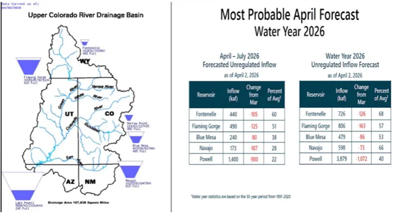
The Salt Lake Tribune notes references an April 1 forecast from the Colorado River Basin Forecast Center stating that Powell will receive 1.4 million acre-feet of inflow this April to July — only 22% of average — which equates to a nearly 1 million acre-feet drop from the center’s March forecast.
The numbers back up WyoFile’s figures, with the Bureau of Reclamation’s March report forecasting Powell dropping below “power pool” or 3,490 feet by the end of December — a level too low for the Glen Canyon Dam to produce electricity.
The bureau has said it is considering reducing flows out of Powell from 7.48 million acre-feet to 6 million acre-feet — the maximum allowable reduction under a 2024 near-term operating plan for Lake Powell and Lake Mead.
The agency has also discussed releasing 500,000 acre-feet of water from Flaming Gorge and other upstream Colorado River reservoirs.
“Those two tools taken together at those levels are not sufficient to prevent Lake Powell from going below 3,500, according to these most recent forecasts,” said Anne Castle, a senior fellow at the University of Colorado’s Getches-Wilkinson Center.
As for what’s causing the poor water supply outlook, Salt Lake Tribune points to record-breaking March temperatures across Utah and neighboring states, and low snowpacks across the same states — the lowest-ever observed snowpack conditions as of April 1.
The article goes on to say that the combination of poor snowpack and high March temperatures led to a “huge snowmelt” that has increased the likelihood of record-low runoff to Powell.
One positive consequence is an increase in soil moisture, due to more rain than snow this past winter, and the fact that high-elevation snow melt happened much earlier than normal this year.
However, the moist soil may not last very long. If hot conditions persist in April and melt the rest of the snow, the state and greater Colorado River Basin will likely see much drier soils this summer, states the Tribune, quoting Cody Moser, a forecaster with the Colorado River Basin Forecast Center.
Supply chain chaos
As the planet continues to warm, we’re going to be in serious trouble for Just-in-Time food supply chains. A lot of food won’t grow where it used to, such as sweet corn grown in the Imperial Valley of California and high-elevation desert areas of New Mexico.
We know what heat does to plant growth. Yields begin to decline at temperatures above 30C for most agricultural crops. We’re also quickly running out of capacity. Norman Borlaugh, the father of the Green Revolution, said the Earth could support 10 billion people if we did everything right.
We’re at 8.3 billion and we’re not doing everything right. As far as I know, Borlaugh never factored global warming into his forecasts.
The Iran war is changing the way we look at supply chains. Consider the introductory paragraph to a recent article by Supply Chain Brain:
The escalating conflict in Iran has already started to ripple through global supply chains, as disrupted shipping lanes, rising insurance costs and the effective closure of the Strait of Hormuz have forced carriers to suspend transits, reroute vessels and brace for higher transportation costs across global trade lanes.
The blog Tarangya declares that the era of “Just-in-Time (JIT)” supply chains is over, replaced by “Just-in-Case”.
Tarangya’s first two paragraphs sum up the situation quite well:
The landscape of global trade in early 2026 looks nothing like the world we inhabited just two years ago. For decades, the logistics industry worshipped at the altar of efficiency. We optimized every second, shaved every cent, and prided ourselves on “Lean” operations. But as the dust begins to settle on the recent regional conflict, the heavy silence at the once-bustling docks tells a different story. The old playbook has been shredded.
For freight forwarders, exporters, and importers, the shift from Just-in-Time to Just-in-Case is not a choice; it is a survival mechanism. Supply chains after the Iran war are characterized by a profound sense of caution. We have moved from an era of “minimum viable stock” to an era of “maximum viable resilience.”
In other words, stockpiling.
Conclusion
We have major problems coming in our food and water supplies and people better be prepared. It’s extremely difficult to move food if global shipping choke points like the Strait of Hormuz are blocked.
Ocean-going perishable foods will not survive delays or alternative routes that add thousands of kilometers and days to the voyage.
Gulf states are 90% dependent on food imports. Over 70% of foodstuffs are imported through Hormuz, which effectively remains closed. The US blockade of Iranian ports has created significant disruption to maritime trade, affecting nearly a million tons of grain and oilseeds.
Prices for staples like rice have already seen massive increases, with fears of further inflation.
Desalination plants have been attacked, dangerously putting civilian access to fresh water in harm’s way.
In North America, the cost of farm inputs like diesel and fertilizer have skyrocketed due to the closure of the strait. 70% of US farmers say they can’t afford this season’s fertilizer. Fruit and vegetables pickers are in short supply due to ICE, bidding up labor costs.
Farmers are like any other business; they pass on any extra input costs to consumers, in this case, grocery shoppers. Food inflation in the US is getting worse. The Department of Agriculture’s latest price forecast published in March projected food prices will rise 3.6% in 2026. This doesn’t seem much, until you realize that inflation is compounded. The 3.6% is on top of 2.7% average inflation in 2025, which is on top of 2.9% in 2024, etc. Meaning food inflation from 2024-26 is actually 9.2%.
The weather is obviously a major factor in food and water availability. The United States just experienced a record-breaking hot March.
The April 14 US Drought Monitor showed 75% of the US is dealing with some level of drought or dryness. The April 23 Drought Monitor says “From the Ohio Valley south into the Southeast, conditions remained quite dry, with little to no precipitation recorded across most of the region. The West was also largely dry, with only coastal areas of California and parts of the Pacific Northwest recording above-normal precipitation.”
Much of the continental US shows soil moisture is in the lowest percentile categories. In the Southeast, crops are being pre-irrigated. Winter wheat crops could be abandoned due to 68% of the acreage suffering from drought.
In Canada, at the end of March, 39% of the country was classified as Abnormally Dry (D0) or in Moderate (D1) to Severe Drought (D2), including 32% of the country’s agricultural landscape.
2025 was among the worst years on record for global ice loss. 70% of the world’s fresh water is locked up in glaciers.
A low snowpack in parts of Canada and the United States is putting pressure on the availability of fresh water.
In North America, the canary in the coal mine for water loss is the Colorado River and its dams that hold back water in major reservoirs. The Colorado River is in crisis, and there appears to be no end in sight.
There is not enough runoff to fill reservoirs, which, if they drop low enough, will prevent power generation. That could result in black- or brownouts to states that rely on electricity from Colorado River dams.
For now, officials are relying on extra discharge from the largest upstream reservoir, Flaming Gorge. But that is only a temporary fix. If levels in that reservoir run too low, and they get another low-snowpack year, Lake Powell could be in worse shape in 2027.
In Canada, parts of British Columbia are also showing lower-than-normal snowpacks, upping the risk of drought, water shortages and wildfires. In 2023, the Western-most province saw 24,900 square kilometers burned, nearly double the 2018 record of 13,600 square km. That’s an area almost the size of Vancouver Island.
It’s nice to believe a wet spring will improve the situation north and south of the border, but the forecast calls for pain not rain. Currently a marine heat wave stretches 5,000 miles across the Pacific Ocean from Micronesia to California, warming waters from 6 to 8 degrees above average. Warming in the Pacific Ocean is characteristic of the El Nino climate pattern. We are currently transitioning from La Nina to El Nino.
There is a one-in-three chance of El Nino taking hold this fall, and a strong likelihood of a “Super El Nino” that would pose fresh risks to global food costs, as well as food insecurity.
A new computer model predicts the development of a Super El Nino (more than 2C warmer than normal) over the equatorial eastern Pacific toward the end of the year.
A strong El Nino generally makes the whole world warmer, as heat wafting up from the ocean gets spread far beyond the tropics. That could lead to a hotter-than-usual summer in the western US, potentially worsening the wildfire season in California and Oregon.
An El Nino event could put upward pressure on cocoa, food oils, rice and sugar, bananas, tea, coffee, chocolate and soy-fed meat.
Closer to home, heat, droughts, fires, water shortages, failed crops and food inflation are all forecasted. As spring turns to summer, residents and businesses should prepare for the worst.
This is a list of all US-traded ETFs that are currently included in the Commodities ETF Database Category.
Richard (Rick) Mills
aheadoftheherd.com

Legal Notice / Disclaimer
Ahead of the Herd newsletter, aheadoftheherd.com, hereafter known as AOTH.Please read the entire Disclaimer carefully before you use this website or read the newsletter. If you do not agree to all the AOTH/Richard Mills Disclaimer, do not access/read this website/newsletter/article, or any of its pages. By reading/using this AOTH/Richard Mills website/newsletter/article, and whether you actually read this Disclaimer, you are deemed to have accepted it.


