 RSS Subscribe
Under the Spotlight – Bruce Counts, CEO Storm Exploration TSXV:STRM
2026.07.13
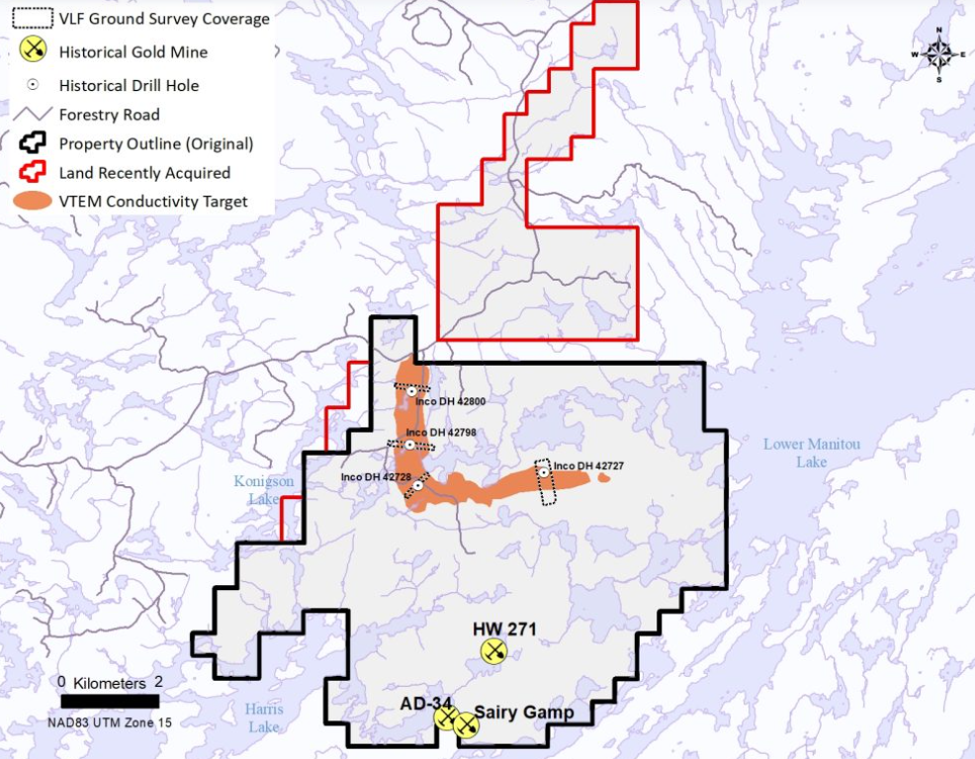
Storm Exploration (TSXV:STRM) had identified a large airborne conductivity anomaly as a Volcanogenic Massive Sulfide (VMS) target at its Gold Standard property located 60 kilometers north of Fort Francis in northwestern Ontario.
In addition, sulfide mineralization, including copper mineral chalcopyrite, has been discovered and the land position expanded. Eighty mineral claims covering 1,672 hectares of prospective geology have been added to the project, which now comprises 369 mineral claims covering 7,636 ha.
Gold Standard
The first phase of a two-phase field program began in May.
The first phase consists of ground geophysical surveying, rock sampling, geological mapping and a property-wide Light Detection and Ranging (LiDAR) survey. The second phase aims to conduct up to 3,000m of drilling.
Storm’s goal is to determine whether a large VMS system, rich in copper and zinc, is the source of the 5-kilometer-long conductivity anomaly identified on the property.
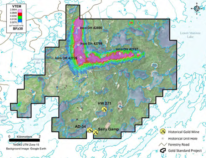
VLF-EM (Very Low Frequency Electromagnetic) data confirms that a strong conductor is present 100 meters below surface that coincides with the 5-kilometer-long conductivity anomaly identified by Storm in a 2024 airborne VTEM (Versatile Time Domain Electromagnetic) survey.
(A VTEM survey is a deep-penetrating airborne method utilizing a large transmitter loop to send pulses into the ground. In contrast, a VLF-EM survey is a shallow-mapping technique that relies on distant military radio transmitters for its signal.)
Sulfide mineralization, including chalcopyrite, a copper-carrying mineral, has been discovered in three separate locations at surface, coinciding with the conductive anomaly.
Why we’re running out of copper
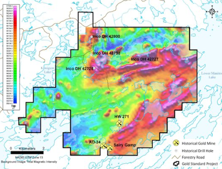
The survey data indicates that the conductors strengthen and widen with depth and coincide with geological contacts between mafic and felsic volcanic units. In addition, faults interpreted from the VLF-EM and VTEM data may indicate pathways for mineralized fluids as part of a VMS mineralizing event.
Crews have arrived at Gold Standard to complete the VLF-EM survey over the VMS target and commence a systematic surface rock sampling program along the conductor.
Geophysical surveying and prospecting are expected to take three weeks to finish.
“The work underway at Gold Standard continues to indicate the potential for a large VMS system on the project,” said Bruce Counts, Storm’s President and CEO, in the July 8 news release. “We are increasingly excited about the upcoming drill program and the opportunity for a significant discovery.”
“Storm has developed an efficient method of evaluating the VMS target and identifying the most prospective drill locations,” Counts continued. “VLF-EM has proven to be a rapid, cost-effective method for mapping the conductor, while geochemical results from systematic sampling of sulphide-bearing surface rocks will help identify the most prospective areas along the target’s 5-kilometre strike length.”
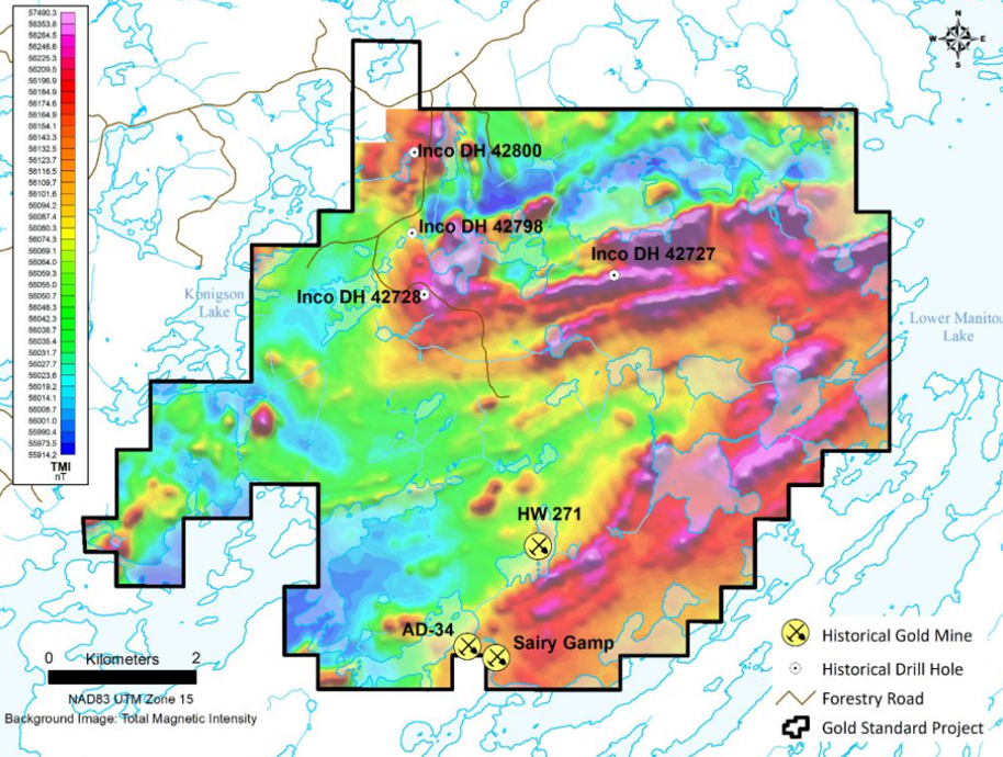
Storm notes that four shallow, small-diameter holes were drilled along the conductive anomaly by Inco in 1969 and 1970. All the holes intersected altered and sheared mafic and ultramafic volcanics with three exhibiting significant disseminated and semi-massive pyrite-pyrrhotite-chalcopyrite-sphalerite mineralization. Importantly, the VMS target remains untested since none of the historical holes intersected the conductor defined by the VTEM and VLF-EM data.
Background
In an earlier AOTH Under the Spotlight interview, Bruce Counts said Storm initially acquired Gold Standard because of three historical, small-scale gold mines that operated near the turn of the 20th century: Sairy Gamp, HW-271 and AD34.
Under the Spotlight — Bruce Counts, CEO, Storm Exploration
“There had been very little follow-up on any of this gold mining that had been done more than 120 years ago. And no drilling. So, that’s what drew us to the area,” Counts told me in March.
The abandoned HW-271 mine is located approximately 4 km south of the large EM anomaly and was mined by Gold Standard Mining Co. between 1902 and 1903.
The old-timers were after the high-grade material and they found it — despite only mining to shallow depths (around 30m) before losing the veins or encountering grades too low to bother with at the time.
What stands out are the grades.
The site has been visited several times by government geologists, including Berger (1988), who obtained relatively high-grade values from samples of sulfide-rich vein material ranging up to 55.9 g/t gold (Au), 29 g/t silver (Ag) and 1.52% copper (Cu).
In 2022, Storm collected surface rock samples in the vicinity of the HW-271 mine and obtained the following assay highlights:
- 166 g/t Au, 197 g/t Ag and 1.47% Cu
- 88.6 g/t Au, 40 g/t Ag and 1.49% Cu
- 83.4 g/t Au, 45 g/t Ag and 0.96% Cu
- 77.6 g/t Au, 45 g/t Ag and 2.59% Cu
Gold mineralization occurs in shear-hosted quartz veins that include minor amounts of chlorite, ankerite, pyrite and chalcopyrite.
Counts and his team were intrigued by the Gold Standard Project, but they were also interested in four holes drilled by Inco, 4 km to the north. Short for International Nickel Company, Inco was a massive Canadian-American mining corporation famous for once controlling nearly 90% of the world’s nickel production. Dominating the global market from its headquarters in Sudbury, Ontario, Inco produced about 25% of the world’s nickel and was the only Canadian company ever included in the Dow Jones Industrial Average. In 2007 it was acquired and absorbed into the Brazilian mining giant Vale (NYSE:VALE).
The four holes were drilled using a “Winkie drill”, a lightweight, portable rig only capable of drilling thumb-sized holes about 50m deep.
While all four holes encountered copper and zinc sulfide mineralization, they were never assayed. Why is not hard to answer, since Inco was obviously only interested in nickel.
Like any good mining CEO would, Counts decided to investigate further. In 2022, Storm conducted an electromagnetic (VTEM) survey over the entire property to measure the conductivity of the rocks.
“The initial purpose of the EM survey was to give us an idea of what was going on with the shear zone that hosts the gold. The primary goal was to extend those gold horizons,” Counts recalled.
“To our surprise there was a very large electromagnetic anomaly that is directly associated with the four holes that Inco drilled. We believe that conductivity anomaly could represent a volcanogenic massive sulfide (VMS) deposit and it will be the focus of near-term exploration efforts at Gold Standard.
“This anomaly is located along an all-weather forestry road. It won’t cost a lot to get out there, do a little bit of prospecting, walk along that EM anomaly and then poke five to 10 holes to see what it is.
“The anomaly is 50 meters across and goes for 5 kilometers. If it is a VMS system with grade, it could be a very important discovery.”
This statement is so important it’s worth expounding upon.
VMS
VMS are interesting deposits because where you find one VMS pod, you’re going to find another. They almost always come in bunches.
Between the Archean and the Holocene — the current geological period – volcanogenic massive sulfides were formed on the ocean floor during ancient underwater volcanic activity. Where the Earth’s crust was thin, magma boiled up, forming volcanoes which erupted minerals that spewed into the ocean. Minerals also escaped through “black smokers”, mineral-rich plumes that blanketed the seabed. Eventually with the movement of tectonic plates, these mineral deposits ended up on land that was once underwater (like the Gold Standard property in northwestern Ontario).
It’s fair to say, then, that VMS deposits have existed since the beginning of the Earth.
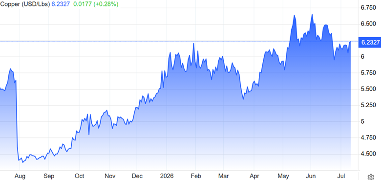
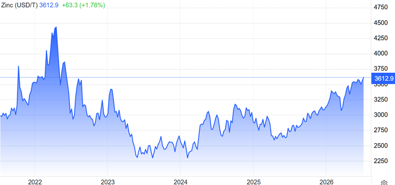
These deposits are sought after for mining because they usually contain a melange of base metals and sometimes precious metals including zinc, lead, copper, silver and gold. The minerals are often clustered together, making them relatively easy to extract.
VMS deposits contain mostly base metals and may have lesser amounts of precious metals such as gold, silver and platinum. They are often major sources of zinc, copper and lead, with gold and silver by-products.
Cobalt, tin, barium, sulfur, selenium, manganese, cadmium, indium, bismuth, tellurium, gallium and germanium may also be found in VMS deposits.
We can see where the term “volcanogenic” come from, since the deposits are formed by underwater volcanoes. The “massive sulfides” refers to the large accumulations of sulfide minerals that form on or below the ocean floor.
VMS deposits usually contain abundant iron sulfides (pyrite or pyrrhotite) and lesser amounts of chalcopyrite, the copper mineral, and sphalerite, the zinc mineral.
VMS deposits consist of a massive or semi-massive stratabound sulfide lens. Most are underlain by a sulfide-silicate stockwork vein system.
Individual massive sulfide lenses can be over 100 meters thick, tens of meters wide, and hundreds of meters in strike length. VMS deposits range from 200,000 tonnes to more than 150 million tonnes and most often occur in clusters.
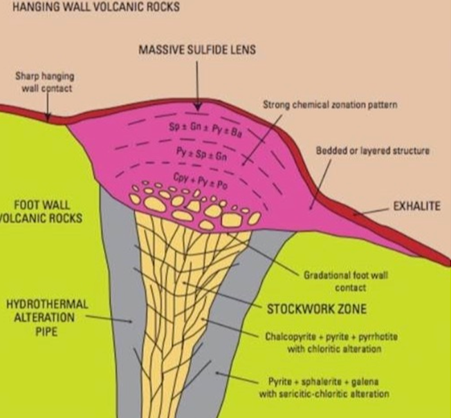
VMS deposits are estimated to have supplied over 5 billion tonnes of sulfide ore. They currently account for 22% of the world’s zinc production, 9.7% of the lead produced, 6% of copper, 8.7% of silver and 2.2% of gold.
Sulfur chokepoint threatens critical minerals supply
An estimated 900 VMS deposits are found worldwide, averaging about 17 million tonnes each. And they are still being formed, mostly along tectonic ridges where plate movements form cracks in the Earth’s crust – allowing a conduit for ancient minerals to travel up through hot liquids and be deposited, through billowing white and black clouds, onto the sea floor.
VMS deposits in Canada include Flin Flon, Bathurst, Snow Lake and Noranda. The Kidd mine in Quebec, the deepest base-metal mine in the world, is a VMS deposit that has been in production since 1966.
VMS deposits have long been recognized, by both majors and juniors, as potential elephant country – and because of their polymetallic content these types of deposits continue to be one of the most desirable because of the security offered against fluctuating prices of different metals.
Canadian VMS mines have deposits ranging from five million tonnes to 20 million tonnes, although the Bathurst No. 12 mine dwarfs them all at over 100 million tonnes.
Twenty economically viable VMS deposits were discovered in the Noranda District over 85 years, including Noranda’s Horne Mine in northern Quebec which produced 11.6 million ounces of gold and 2.5 billion pounds of copper from 1927 to 1976.
The Flin Flon Greenstone Belt hosts 27 VMS deposits containing predominantly zinc, lead, copper and gold. It originally contained over 154 million tonnes of ore.
Storm Exploration’s 2026 field program includes ground geophysics, mapping, prospecting and soil sampling, followed by 10 to 15 core holes totaling 2,000m to 3,000m.
Gold Standard hosts a 5 km-long conductive anomaly identified by Storm in airborne (VTEM, LiDAR) survey and ground survey (VLF-EM) data and interpreted as a potential VMS system.
The program is being carried out in two stages: target evaluation and drilling. Phase 1 involves ground geophysical surveys to increase the resolution of the EM anomaly; and geological mapping, prospecting and soil sampling to identify the most prospective sections of the anomaly.
In Phase 2, 10 to 15 core holes will test for the presence of precious metals and critical minerals, as well as determine the dip and thickness of mineralization.
Phase 1 started in early June. Processing and interpretation of the geophysical data and geochemical samples will follow completion of the field work. The phase 2 drill program is anticipated to begin once the supporting data has been received.
Counts says Storm will have drill targets by the end of July, with drilling likely to start at the beginning of August.
My own take here is that Storm has potentially come across a unicorn: an undiscovered massive sulfide deposit buried in plain sight; sitting beside a shear zone 4 kilometers away containing high-grade gold, silver and copper. Gold up to 166 g/t Au, silver up to 197 g/t Ag, and copper up to 2.4% Cu. Incredible.
To be clear, it hasn’t yet been confirmed that the conductive anomaly is a VMS deposit. Only drilling can prove that. But we have a 5-km-long anomaly that runs 100m deep by 50m wide, as confirmed by geophysical airborne and ground surveys. The cherry literally on top is that sulfide mineralization has been discovered in three separate locations at surface, coincident with the conductive anomaly.
Storm’s focus, and rightly so, is the 5-km conductive anomaly that Counts and his team identified through geophysical surveys. The goal is to determine whether a large VMS system, rich in copper and zinc, is the source of the anomaly.
So far, VLF-EM data confirms that a strong conductor is present 100 meters below surface that coincides with the 5-kilometer-long conductivity anomaly identified by Storm in a 2024 airborne VTEM survey. The next step is to drill it.
But Storm isn’t forgetting about the gold-silver-copper project 4 kilometers to the south with eye-popping grades. Three historical mines have never been explored with modern techniques.
Storm has two bona fide targets that, imo, are both company makers.
The company is sitting on roughly $12 million cash and just announced a financing that aims to raise an additional $2.5 million.
A great project in Gold Standard led by experienced management, combined with a low outstanding share count and a tiny market cap makes STRM a top AOTH pick.
Rick Mills, Editor/ Publisher, Ahead of the Herd:
Bruce let’s do a deep dive into Storm’s Gold Standard Project, and both it’s stand alone, any company, flagship pieces, a potential very large VMS and the Gold Standard Mine.
Bruce Counts, President and CEO, Storm Exploration:
The big thing is here is if take a step back, we’ve got this big conductivity anomaly, and along that entire 5-km-length we have these four holes that have were drilled in 1969-70. That’s the basis for our target. What are we targeting? It’s this big conductor, so how do we get the best resolution on where it says how big it is, what its shape is, where exactly it is in space?
We do that by going from the airborne survey because when you fly with an airborne survey your sensor may be 50 meters off the ground for the sake of argument. If you can get your sensor closer to the ground of where that conductor is you get much better resolution. You can really see exactly how wide it is, what it’s doing as you go deeper. Is it moving around? Is it faulted? Is it broken? How thick is it? All of these things come into much sharper focus when you do the groundwork.
RM: In the north of the property,we’ve got this big conductivity anomaly, but what exactly is it and what does it mean to the average investor, shareholder to discover something so strong, like this one lights up, under plenty of sulphides on surface?
BC: Right, when we’re measuring the resistivity or the electromagnetic signature of a rock, really what we’re finding out is how well does that rock conduct electricity? Most rocks don’t conduct electricity very well.
Sulfides are metalliferous minerals — it’s like adding metal to the rocks. It becomes more conductive. So, the more metal you add the more conductive it becomes.
Now there’s some other minerals out there that are conductive, like for example graphite. Sometimes you can get fooled, you could have graphitic horizons that are also conductors. What I think is really important here, we’re in the 85 to 90% confidence range that this conductor is due to sulfides because of its strength and its size. On top of that, right over where the conductor is we’ve got sulfides that we actually see in the rocks. The strength of the anomaly itself can really only be explained by the presence of sulfide minerals, which are these conductive minerals that are in the rocks. The more there are the more conductive it becomes.
RM: Just to follow up, an interesting point in the news release was that you mentioned those four drill holes and the sulfide results in them — up to 20 meters of copper and zinc massive and semi-massive sulfides — they didn’t show up strong enough to explain the conductor underneath. In other words, they showed up as weak overtop of a strong conductor underneath.
BC: There’s a couple of things: the sulfides we’re seeing at surface definitely are not in a high enough abundance to explain that conductivity anomaly that we see. The conductivity anomaly that we see with the VLF as well as with the airborne system says to us that it gets more conductive as you go deeper and it gets a bit wider. We’re thinking that when you look at the way those holes were drilled by Inco, first of all, none of them were deep enough to penetrate the most conductive part of the conductive horizon.
The other thing that’s important is when you map out where those holes were with respect to where we did the VLF, is in in every instance none of them were deep enough to hit the conductive horizon, and a couple of them were going to miss it even if they had kept going down. They just hadn’t quite aimed them properly and that’s probably because they didn’t have that extra resolution that we have the benefit from getting on the ground.
RM: Two things here. It’s important to note that Inco was looking for nickel. They didn’t care about copper or zinc.
BC: That’s our understanding, correct.
RM: And two, these deeper, wider intersections that you can differentiate out of the total conductor in your surveys are drill targets. They’re natural drill targets to focus on in the first drill pass.
BC: Yes. The VLF that we’re doing we use an instrument called an EM-16; it’s very lightweight. It can be held and carried by one person. So, you can deploy this and move it very quickly over the anomaly. It’s very effective in giving us that resolution that we’re looking for. In geophysics they have a thing called skin depth, which is how deep will this technique see? About 100 meters is what you can be reasonably confident you’re seeing.
It’s great data and it’s so fast. Rick. There are a lot of EM techniques out there. Some of them you might get a clearer picture of what’s going on at depth, but they tend to be very slow, very expensive and kind of cumbersome to move around. So, to have something that is quick and lightweight and gives you a rapid answer down to 100 meters is perfect for what we’re trying to achieve.
RM: We’ve got 5 kilometers of continuous conductor, that’s a large area to pinpoint drill hole locations, how does the EM-16 do that?
BC: Well, we need to understand what that conductor looks like at surface and down to 100 meters. And then the next component of that is where along this 5 kilometers do we have our best shot at hitting important metals like copper and zinc? Copper and zinc is what we’re confident we’re going to see because there were copper and zinc sulfides in all of those Inco holes.
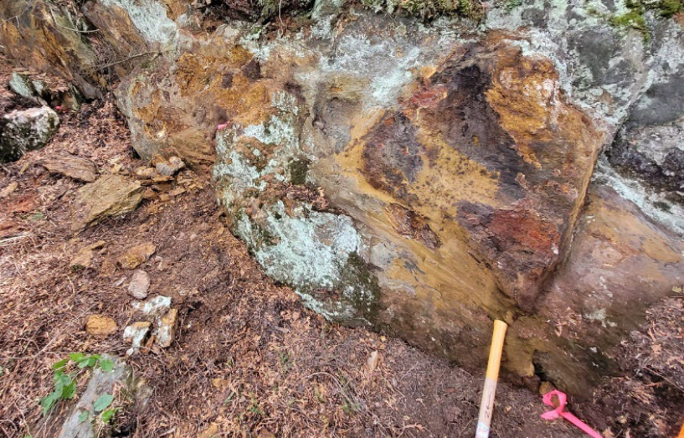
The fact that we’re finding sulfides at surface is really important. It serves as a few things. First, it increases our confidence that these conductors are because of sulfides. Two, that this could potentially be a volcanogenic massive sulfide system and if so it’s very large. And three, and this is the most important aspect, is while we’re not going to see continuous exposure of sulfides and outcrop all the way in that 5 kilometers, it appears like there’s going to be enough that we’re going to be able to find some kind of geochemical footprint of what this thing looks like over the 5 km.
So, those samples are going to tell us where we have the best shot at hitting our suspected high-grade copper and high-grade zinc, and where we are in this VMS system. In terms of how we can target this thing geophysically is what we’re pointing the drill at, and then where along the 5 km we want to be the geochemistry is going to tell us where’s the best place to poke holes.
RM: I’m having a hard time visualizing how this VLF-EM survey is conducted. The 16 is so small and light where does it get the signal it needs?
BC: Usually with electromagnetic surveys you need some kind of electromagnetic source. What this system uses are submarine navigational beacons that are set up around the world. There’s one in Seattle. There’s one in Maine.
Seattle and Maine are the ones we’re using here. Those stations transmit a very low-frequency electromagnetic signal that goes around the globe and you’re using that as your source to energize the conductor. There’s no wires that are laid out on the ground, it’s just an instrument that you carry that tunes into that and uses that signal from those navigational beacons to measure conductivity. It’s something that’s been around since the early ‘60s if not the late ‘50s.
“The EM16 VLF Receiver is the most widely used electromagnetic geophysical instrument of all time. Local tilt and ellipticity of VLF broadcasts are measured and resolved into inphase and quadrature components of VLF response. The EM16 has discovered several base and precious-metal ore bodies and many water-bearing fractures and faults.
The EM16R Resistivity Attachment uses a pair of electrodes to measure the apparent resistivity of the earth. The combined EM16/16R instrument can detect a second earth layer if the layer occurs within the VLF skin-depth. In addition, the EM16/16R can map resistive alteration for gold exploration.”
RM: The VTEM survey, that’s more of a locator survey. You fly that and you kind of get zoned in. And then the VLF takes what you’ve zoned in on and looks at it.
BC: Well, with airborne you can cover the whole property and get a big picture of what’s going on; you get electromagnetics as well as conductivity. But if you want real resolution to understand… you’ve identified the big anomaly, now you want to get closer… it’s like having clearer glasses and seeing what does it really look like? You get down on the ground with an EM system. It’s a similar system. It’s using electromagnetics to measure conductivity. You’re just closer to the ground and it’s using different signals to do that, right?
RM: You’re working up some pretty serious drill targets from the way the exploration was conducted.
BC: I was asked the question today, “If you had to stop today, do you have a drill target already?” The short answer to that question is yes, I think we probably do because we’re seeing copper sulfides at surface. If we did nothing else we could just drill under that. Obviously there might be better places along this 5 kilometers where there’s even more copper sulfides at surface so it’s in everybody’s best interests for us to take a very systematic approach to sampling this thing over the 5 km, but we’re already seeing what we want to see in terms of what are the ore-forming minerals here? And where’s going to be the sweet spot?
RM: You don’t find a lot of VMS on surface.
BC: There’s a few things that make this unusual: the fact that it’s so large, 5 km of continuous conductivity, that’s a very large system. The fact that it’s been sitting here hiding in plain sight for the last 55 years is another thing that’s remarkable. And a there’s a road that goes right over it too. But it’s pretty evident that no one has been here since 1969-70.
In terms of early-stage exploration this is about as good as it gets; all of the evidence we need to keep moving forward is there. As an early-stage explorer one of the things we need to always keep in mind is you don’t want to fall in love with your project. My approach always be looking for the fatal flaw. Look for the thing that tells you that your thesis is wrong. Don’t be afraid to admit that you’re wrong.
If you’re going in with a thesis that this is VMS then look for things that tell you it’s not. So far everything that we’re doing and everything that we’ve done, everything we’re seeing has said this walks and talks like VMS. We’re not going to be able to be definitive until we get drill holes into it. But certainly, everything we’re doing and seeing at surface and the historical work makes us say this looks a lot like a VMS; our confidence is increasing day by day.
RM: How does your LiDAR survey, the first survey you did fit in here?
BC: We flew the LiDAR just before we put people on the ground so we can see where the rocks are, where all the outcrops are, and the big structures. And then again, guiding that geochemical program where we’re actually on the ground collecting rocks.
Say you find a sulfides horizon and it’s 10 meters across. We’ll be taking a sample of those rocks every meter across that 10 meters. So, then we’ll get a geochemical picture across that conductive horizon And we’re going to do that all the way along the 5 km wherever we can find those sulfides at surface. That’s bringing us that geochemical picture in a nice systematic and structured way.
But LiDAR does a few different things. Probably the most important is it gives you a really detailed, digital terrain model. So, in other words, it’s measuring the surface of the Earth. It’s blind to vegetation so you’re seeing basically the shape of the ground. It won’t see through snow so you have to wait till the snow is gone. But now we can see exactly what the ground looks like as if you could remove the trees.
That is so important for structure, for geology and lithology, you throw that together it’s like having an extra layer. You’ve got your electromagnetics telling you about conductivity We’ve got magnetics now as well and we had the LiDAR which gives us a nice digital terrain model.
That helps us to understand the structural environment and the geological environment that we’re working in. Structure is going to be really important here because structure is like the plumbing that brings all those sulfides to surface. So having a good understanding of structure is really important.
RM: Understanding structure is always so super-important, especially with VMS, why?
BC: You always want to know as much as possible about the system and where you are in it. VMS systems are zoned. They have a vent(s) where the vent is throwing out these metals-rich fluids and the copper comes out of solution really close to the vent. And then as you get farther away the sulfides tend to get smaller, a bit more fine-grained. You lose the copper and you start to pick up the zinc. Closer to the vent you’ll have thicker pile because that’s where the all the metals are falling out right away. That’s where you’re going to get most of your copper and those vents have the long structures. So, understanding structure is super-important.
RM: You’ve got four things going on here. You’ve got the VTEM for the kind of bird’s-eye view. You’ve got the VLF-EM for high resolution and depth, you’ve got the LiDAR and then you’ve got the surface sampling.
BC: That’s right, LiDAR is helpful for structure along with magnetics is helpful for structure. The VTEM survey collects not only the conductivity, like the VLF type of data, but it also collects magnetic data at the same time. So that, along with the LiDAR, gives us our geological and our structural picture.
My guess is we’ll have pretty good idea of targeting by the end of this month, with the drilling to start consecutively also into this month/ beginning of August.
RM: The old axiom is it takes 2-4,000 meters to really get a handle on what you have. You’re planning on up to 3,000 meters and you’re moving along quickly.
BC: We’re excited. The company’s been dormant for a long time sorting out things with first nations, but I’m super excited to be doing some exploration and this is a really exciting target. It’s higher risk because it’s earlier stage, but it’s sure got all the signs of a great big VMS system. And if it is and it’s got grade it’s a company maker.
Like I said, for an early-stage explorer it doesn’t get much better than this. We’ve got all the signs that we’re on to something big that’s never been found before. So, it’s a true brand-new discovery.
It’s right at surface, it’s so continuous over the 5 kilometers. And it’s big, right? All I could say is if this thing’s got grade it’s big. There’s likely multiple vents along this 5 kilometers. There could be one big mother event but I think it’s much more likely we’re going to find several vents along the 5 km assuming that we are correct that it is VMS.
RM: What is the potential for this being a gold-rich VMS? There is a reasonable point to be made here that could potentially become even more compelling to get this conductor drilled.
BC: Right now, there’s no direct evidence that there could be a gold component here. The holes that were drilled by Inco were never assayed so we don’t know if there was any gold in those holes. We’ll have to wait and see what sampling that we do brings to the table.
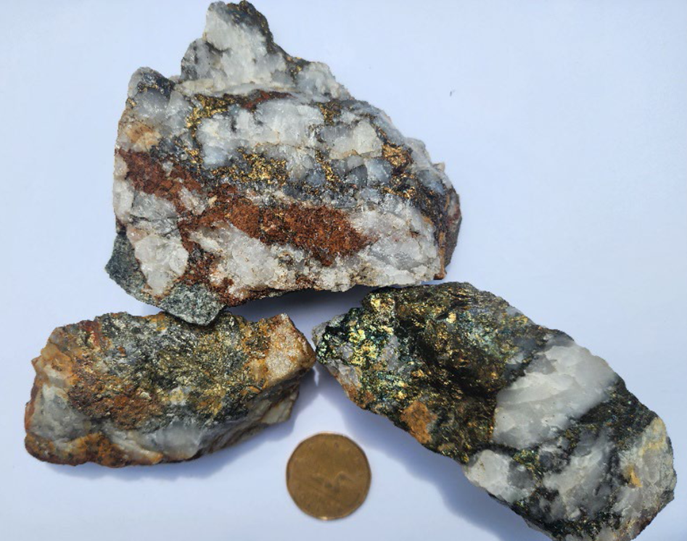
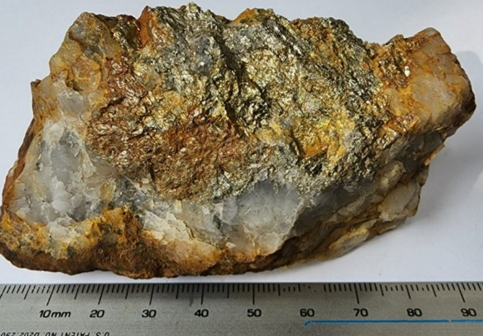
The compelling argument that there may be a gold component here is that 4 kilometers away from this massive 5-km conductor is this HW-271 also known as the Gold Standard mine, which is where the project gets its name from. When we sampled the sulfides that were mined there… there’s still sulfides you can grab on the surface right around where that mine was. It ran 166 grams per tonne gold, 197 grams per tonne silver and 1.47% copper. That’s just one of the samples that we collected.
So, you’ve got that high-grade copper in the sulfides, in these quartz lenses.
This is 4 km away along with the gold and the silver. There’s no direct evidence it’s going to be in that big conductor, but it’s easy to imagine that a system that’s big enough that it creates a 5-km-long conductor that 4 km away there might be some leakage.
Is it part of the same mineralizing system? We don’t know but it’s very compelling, particularly given that there’s high-grade copper with those free gold results.
I know what they were mining would have been 1901 to 1903, right? We’ve got a couple of samples where you can see visible gold. There’s no real historical documentation on what the grades were, I read it was 55 grams per tonne was what they were mining back in the day.
RM: A small high-grade lens, right?
BC: Exactly. But the intriguing thing was it had copper in it, it’s just so unusual to see the copper sulfides in those lenses. The results from our sampling list was that there were there quite a few that were pretty good numbers coming out of the sulfides from that particular mine and they all carry high-grade copper.
- 166 g/t Au, 197 g/t Ag and 1.47% Cu
- 6 g/t Au, 40 g/t Ag and 1.49% Cu
- 4 g/t Au, 45 g/t Ag and 0.96% Cu
- 6 g/t Au, 45 g/t Ag and 2.59% Cu
RM: What else could that have been caused by Bruce? Those quartz sulfide lenses?
BC: It’s a geologically complex area. The reason why the conductivity anomaly looks the way it does is because it’s been folded. Those gold mines are located on what’s called the Manitou Stretch, that’s a 100-km-long shear zone that’s up to 3 kilometers wide. It’s a massive crustal break and it’s pretty clear that the geology where that conductor is, as that shear zone moved along it probably dragged that geology around and created that fold.
When did the mineralizing event happen? It’s when the metamorphosis and all the folding and faulting happened. Did you get remobilization of fluids and some of it popped up a little bit 4 kilometers away? It’s really early stage, Rick to be able to answer that question. Proximity is the only thing that we really have right now.
When we staked this ground originally I liked those gold mines because nobody had ever done any drilling around them. The historical record… the government of Ontario had gone in and collected samples just like we had and had similar results. I just thought you don’t get such high-grade juice and just get little pinpricks of it showing up without there being some more somewhere else. Like, that’s a lot of juice to just have a couple of pinpricks.
And so that’s why we took the area on. I never expected we’d see the EM targets that we did see but for me… like again there’s nothing definitive to tie these two things together as one mineralizing event or being part of the same system. But it’s very compelling given their proximity and the occurrence of high grade copper in those sulfides that’s a gold mine.
RM: Look, when you get grades like that in the early 1900s the old guys they knew how to find high-grade. They did not care about low-grade because it wasn’t economical for them to chase and that’s it. So, you’re sitting there and you’re looking at those kind of grades. Well, they’re going to move heaven and hell to get at that. But when they run out they run out because they’re not going to chase anything that we would consider economic today.
You’re chasing the conductor. But the gold Standard mine is worth bringing some stuff in at a later date and having a real hard look at it.
BC: No question. That’s what brought us to this project in the first place with those high-grade gold mines that nobody had really explored. Certainly, what has taken our attention is this massive EM anomaly and obviously the ease of it of exploring it because it’s right along the road. But you’re right. We can’t ignore those gold mines — there should be more of that somewhere. Seeing that much juice and in such a small location, there’s got to be more around.
RM: You can build a company off of that. I don’t know if you’re going to hit, but you can build a real junior explorer company off that Gold Standard gold mine because it has never been worked with modern methods. And look at those grades. That could be surrounded by a halo of one gram, 1.5 g/t gold, a little bit of copper and maybe an ounce of silver; that is a righteous target.
BC: Absolutely. And yes, is there more along the trend? Because there’s a big shear zone that that thing is located on. So, there’s definitely potential even right at the old mines, but also elsewhere along that shear zone on the property. Right now, for us the low-hanging fruit is this VMS target.
RM: Agreed, the VMS is the biggest target, it’s the easiest to see and pick out a drill program with targets. How much does Storm own of that shear zone?
BC: We’ve got a couple of kilometers of it; it’s big shear zone. Like I said, I think it runs the better part of 100 kilometers. We definitely have a nice chunk of it and again the reason why is because of those old gold mines. Again, nobody’s ever done any drilling.
RM: To find the Gold Standard mine and the old guys and those grades and have that shear zone, and then go further and find this conductive anomaly, that’s a hell of a story. If you’re gold sampling shows gold in the surface sulphides it adds another dimension the story, those assays should start coming back soon.
BC: Yes it’s all very exciting stuff and I can tell you I’d be happy to take a victory lap if we get a win out of this one.
RM: Bruce, thanks for doing this. It’s been a pleasure talking with you.
BC: Thanks Rick.
Storm Exploration Inc.
TSXV:STRM
Cdn$0.44 2026.07.10
Shares Outstanding 21.4m
Market cap Cdn$9.45m
STRM website
Richard (Rick) Mills
aheadoftheherd.com

Subscribe to AOTH’s free newsletter
Richard does not own shares of Storm Exploration (TSXV:STRM).
STRM is a paid advertiser on his site aheadoftheherd.com
This article is issued on behalf of STRM
Legal Notice / Disclaimer
Ahead of the Herd newsletter, aheadoftheherd.com, hereafter known as AOTH.Please read the entire Disclaimer carefully before you use this website or read the newsletter. If you do not agree to all the AOTH/Richard Mills Disclaimer, do not access/read this website/newsletter/article, or any of its pages. By reading/using this AOTH/Richard Mills website/newsletter/article, and whether you actually read this Disclaimer, you are deemed to have accepted it.