Getchell Gold chasing Carlin-style gold at Fondaway Canyon

2020.05.12
Getchell Gold (CSE:GTCH) announced on October 17, 2019 a binding letter of agreement with Canarc Resource Corp. (TSX:CCM) to acquire Fondaway Canyon. Fondaway includes 136 contiguous, unpatented mining claims, covering about 2,220 acres (898 hectares), or 3.5 square miles in Churchill County, Nevada.
A 2017 technical report denotes 409,000 oz of indicated resources grading 6.18 grams per tonne, and 660,000 oz inferred grading 6.4 g/t, for a combined 1.1 million ounces.
The high-grade resource begins near surface and is open at depth and along strike.

The 2017 NI 43-101 resource estimate is based on an underground mining scenario, with a cut-off of 1.8 meters (6 feet) horizontal width and = or >3.43 g/t.
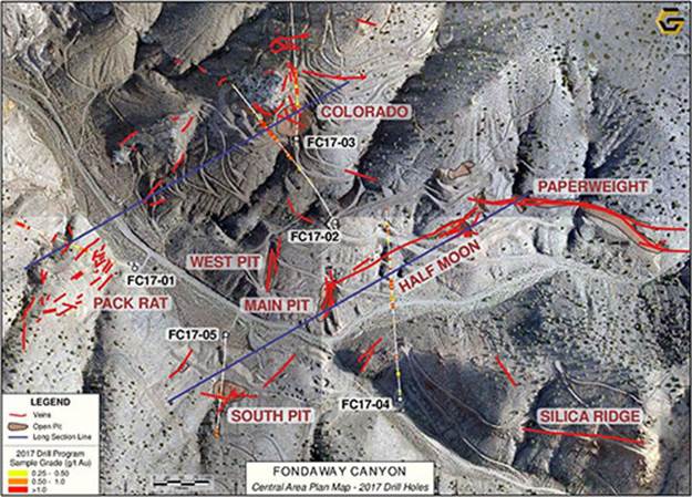
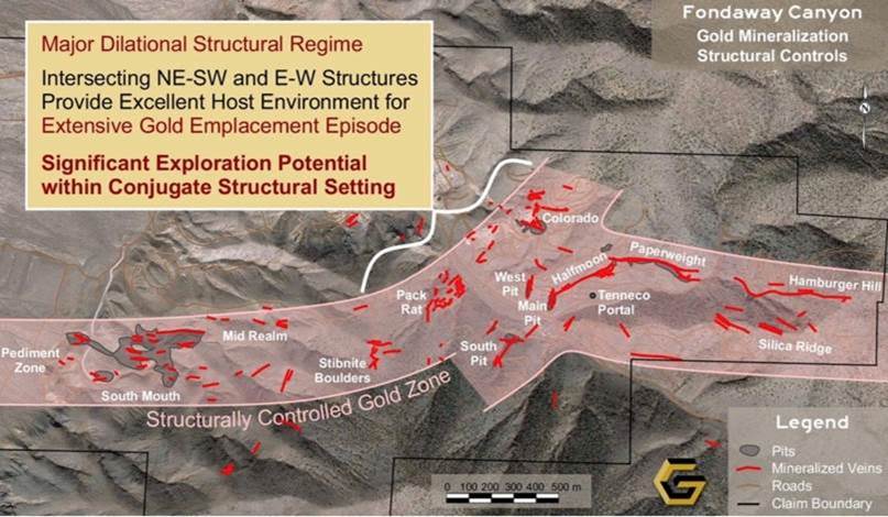
The entire project can be visualized as a vein swarm close to surface, with many veins trending east to west, shown in red in the map below.
All of this is very impressive.
But what really stands out to us at Ahead of the Herd (AOTH), is the opportunity to add significantly more ounces if the structures, and ultimately the source (a potential Carlin-type disseminated gold system), of Fondaway’s extensive sulfide epithermal vein system can be identified, mapped and drilled.
Open pit & underground
The 2017 technical report envisioned an underground operation and set the model parameters accordingly. Getchell is currently completing a new Fondaway technical report. This may change the exploration focus for a new open-pit mining scenario and ultimately, a new mineral resource estimate.

Cut-off grade
One way to add significantly more ounces is to change the cut-off grade. Put simply this means that any grades below 3.43 g/t were excluded from the resource estimate.
For ounces to be included, they had to be at least 3.43 g/t. (the cut-off grade is also known as the break-even grade) In Canarc’s 1.8m-wide section, which runs mostly through the Paperweight, Halfmoon and Colorado zones, there were gold grades higher, and lower than 3.43 g/t; but the average grade was 6.29 g/t (average grade of indicated and inferred resource).
Plugging in dollar figures establishes the per-tonne value of the ore. Using US$1,250/oz gold (Canarc used $1,250/oz in the resource estimate) yields $40.32 per gram ($1,200/31 grams per ounce). Ie., if gold was $1,250/oz, anything less than $138.29 a tonne (3.43 g/t x $40.32) over the 1.8m horizontal width was uneconomic to mine.
Now, if we drop the cut-off grade, the Indicated and Inferred grades will be lower, but the number of ounces will definitely rise. With a higher gold price of say $1,550 per ounce each gram is now worth $50 ($1550/31g) so the same $138.29 breakeven allows the cut off to drop to 2.76 grams Au, which could add nicely to the existing ounces in the resouce estimate.
Interestingly enough Fondaway could also have a very attractive open-pit scenario that would need far lower grades to be profitable than the underground model used by Canarc.
Using this example, Getchell’s indicated and inferred grades would drop from the average of 6.29 g/t, but, the lower cut-off grade will capture more ounces, perhaps significantly more than the Indicated and Inferred (I&I) 1.1 Moz identified in the 2017 resource estimate.
Pediment zone
The most intriguing option for adding ounces, and what could be underpinning the entire structurally controlled gold zone all the way to Hamburger Hill, is the Pediment zone, appearing at the left edge of the map below.
From the 2017 technical report,
Much work remains to integrate the western portion of the project area, which has a correspondingly sparse and predominantly shallow drill history, along a one-mile corridor to the South Mouth zone, the area of previous surface mining. This corridor has detailed rock and soil geochemistry, with several areas of highly anomalous gold geochemistry suggesting continuity of gold mineralization through this zone. The South Mouth zone, where mining excavated the shallow oxide mineralization, has not been explored sufficiently to quantify the down dip extension of the sulfide mineralization to depth.
It is really exciting what happened when a former lease-holder, NCI, step-out drilled into the pediment – visualized as a flat plain, the Carson Sink, that fronts the hills and valleys where the rest of the targets are dotted throughout.
Underlying the plain is about 25 meters of alluvial (gravel-bed) cover, making for easy overburden removal.
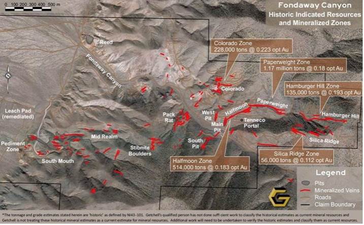
Two holes drilled only 180m apart, in the pediment west of the South Mouth pit, each pulled up significant mineralization – one hole had 0.74 grams per tonne over 30 meters; the other was 0.6 g/t. While those grades aren’t enough to energize gold investors, there is a good possibility that the deposits found in the mountains are just the “smoke” from a major gold system that originates underneath the pediment.
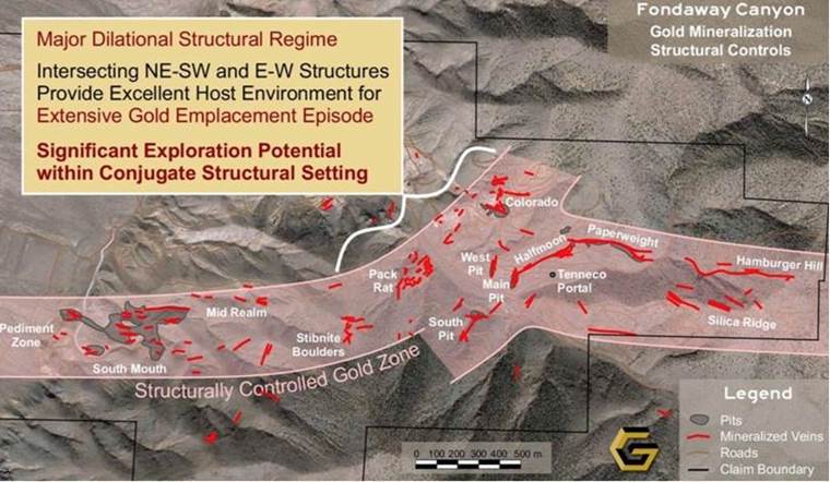
Visualize a heat source millions of years ago squeezing boiling-hot fluids from west to east through the fissures and faults of the earth’s crust, depositing gold and silver minerals all the way from the westerly range-front, several kilometers up into the mountains as far as the Hamburger Hill and Silica Ridge zones.
In Nevada this is a familiar geological model – one that led to discovery of the Pipeline and South Pipeline deposits that became the Cortez mine.
Mining at Cortez currently encompasses three open pits – Pipeline, Crossroads and Cortez Hills – plus three underground zones. A 2019 report shows 8.7 million ounces of gold reserves are contained within underground and open-pit operations, graded at 1.5 grams per tonne, plus stockpiles. Another 705,000 ounces at 1.67 g/t are in measured and indicated resources.
Cortez and Barrick’s Goldstrike mine are operated as an integrated complex under Barrick Nevada. In 2018 it produced 2.1 million ounces. Goldstrike has 8.5 million ounces in gold reserves. A plan to expand the Cortez underground mine known as the Deep South Project is expected to contribute to production starting next year. Mining at Cortez is expected to last until 2031.
Deposits on the shoulders of the hills behind Cortez were mined for decades before drills pierced Pipeline. The geological model used to find Pipeline, the same theory that might apply at Fondaway, is predicated on the notion that larger deposits are found in the basin bottoms, than in the upper parts of the geological system – like mountain ridges.
Testing that thesis would require further drilling into the pediment – looking for the engine driving the whole gold system.
“These results should be followed up with additional drilling to determine if a bulk tonnage, disseminated gold deposit exists in that area, or potentially offset extensions of the Fondaway Canyon vein systems,” states the technical report.
Tracing fluid flow
Fondaway Canyon might be hiding some exciting secrets.
Consider:
- Widespread mineralization is what you need to create open-pit mine environments
- Multiple zones running in many different directions is evidence of a giant system
The fact that at Fondaway there are multiple zones with mineralization going in different directions, shows that from a geological perspective, every open crack that was available during gold emplacement was filled. Fondaway is not one of those situations where you have two, three veins and they’re all running along the same crack, or parallel cracks in a certain direction. Here you have veins where, in every single piece of open space – no matter the direction – that was available for fluid to flow, the fluid went there depositing its precious metals along the way.
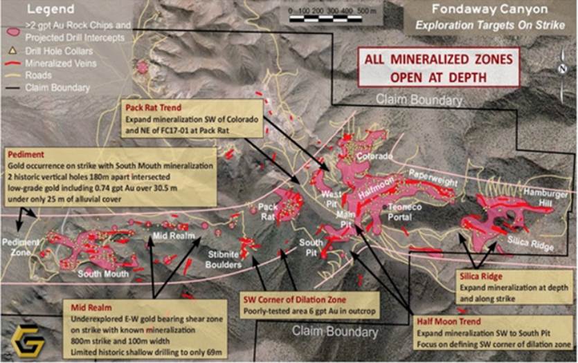
When looking at the map above, it is tempting to see the pink areas as “blobs” of mineralization, perhaps analogous to a porphyry-type deposit hosting a lot of low-grade material. However, this would be incorrect. The blobs are actually groups or swarms of veins, or veinlets, that are all dipping in different directions.
It’s pretty obvious we are talking about a massive amount of fluids coming from a big source. The big mystery to unravel, is how did the gold get there?
Sure, you have your dominant zones and dominant directions, which you can see on the map with all the vein orientations and different fragments, but you don’t necessarily want to mobilize drills and sample every one of these veins. What you want to do is use the main fabric of the structure to focus on the source driving the fluids into every one of these cracks.
As you get closer to that source, you’re likely to be deeper, and into an environment where the structures are tighter, the fluid is more concentrated, and there are bigger volumes of higher-grade deposition, because the fluids stayed there for a long period of time as they flooded into the upper geological units and all the smaller cracks, which now appear as veins and veinlets.
Again, referring to the same map, we see both a structurally controlled gold zone between the Pediment zone and Pack Rat/ South Pit zones, and a major dilational structural regime, between Pack Rat and Colorado, which could host extensive gold emplacement. You can easily see there are two zones coming together, two very prolific zones crossing each other at an oblique angle, in the Halfmoon area.
Is there a massive heat source underneath these zones? To me this is an ideal place to target a deep drill hole and follow the intersection of those two structures to depth.
Or is the source out west in the pediment, where boiling-hot fluids squirted from west to east like squeezing a tube of toothpaste, through the fissures and faults of the earth’s crust, depositing gold and silver minerals from the westerly range-front, several kilometers up into the mountains as far as the Hamburger Hill and Silica Ridge zones?
The short answer is we don’t know. Yet.
What we do know is there are generally two models that explain how fluids, pregnant with gold, find their way into veins and structures.
The first model involves deep breaks in the earth’s crust. Driven by extreme heat and pressure from the earth’s mantle, gold-bearing fluids travel through these crustal breaks for long distances – up to 20 km in some cases – where they end up as veins in the upper crust. An example of this type of gold emplacement is the Archean greenstone belt hosting the Red Lake underground gold mine in western Ontario.
This is quite different from the Nevada environment, where the “engine” of the fluid flow isn’t the mantle; rather, there are hot spots within the upper crust that mobilize the fluids. The fluid penetrates existing rock, crystallizes, and solidifies into gold-bearing “intrusives”.
In a classic Carlin-style gold environment, the fluids have flowed into sandstone units, which were previously deposited into an underwater sedimentary basin. The basin has bits and pieces of lime and fragments of calcium carbonate, from the shells of organisms that died and fell to the sandy ocean bottom.
As the fluids find their way into this environment the calcium triggers a change in the pH of the water, as well as the eH, which is the fluids’ electrical charge. The combination of these two reactions encourages the gold to drop out. It also gives gold places to drop into – as the calcium reacts with the fluid it creates voids in the sandstone, into which the gold is deposited. A mass of fluid soaks into these porous sandstone sediments, and by reacting with the carbon and calcium it coaxes out the gold and creates more fluids that push further out into the system.
Getchell’s job is to figure out whether its project fits the picture of this kind of a big system, and if it does, how do they find the pathways that carried the gold from a presumably much larger deposit, below the near-surface mineralization?
Equally important: Where is/ are the intrusive(s)? Ie., the igneous rock potentially hosting hundreds of meters of mineralization. The trick is finding the main conduit hosting the mineralizing fluids to depth, or on strike which may have soaked into the right age of sandstone along their path. It is likely going to be parallel to one of either the east-west conduit from the Pediment Zone to Hamburger Hill, or the 60-degree offset from the Stibnite Boulders zone to the Colorado zone.
That’s why Getchell needs to chase the system at depth and along strike.
Mineralization
From the 2017 technical report: Mineralization is characteristically a gold/silver ratio of greater than 1:1 and is associated with the sulfide minerals of pyrite, arsenopyrite, and stibnite with lesser amounts of chalcopyrite, tennantite/tetrahedrite, sphalerite, and galena. Gold/electrum is mainly identified as inclusions within pyrite of hydrothermal wall rock replacement and silica/carbonate-rich fracture-fill/breccia cement assemblages, in places in close spatial association and intergrowths with chalcopyrite, sulphosalt minerals and arsenopyrite.
Shale and ardillite are fine-grained sedimentary rocks that are tightly packed together – fluid doesn’t move through them. Sometimes units of shale lie overtop of sandstone, capping the fluids underneath. If these fluids sat for a long time in porous sandstone, there could be a monster Carlin-style deposit lurking underneath the vein swarms.
If that’s the case at Fondaway, and there is gold in the sandstone, how did it get up to the veins near surface? This happens wherever there is a break in the shale, allowing the trapped gold-bearing fluids to flow into the upper stratigraphy. The gold is deposited into rock fractures, becoming veins.
There are two ways forward with the veins at Fondaway Canyon. One is to follow them to depth and see whether the mineralization becomes stronger in more cohesive structures. A second way is to investigate whether the veins change composition as they snake into different geological packages. Ideally they get into even more receptive host rock, ie., a district-scale, Carlin-style gold deposit.
The fact that Fondaway Canyon has stibnite boulders on the property is very encouraging. Most Carlin-style environments are gold, arsenic and antimony. Numerous zones at Fondaway have arsenic – the Pack Rat zone has the most. The combination of arsenic and antimony (stibnite) is a strong indicator of a big system – one that has the right temperature, the right pressure and the right chemistry to be a Carlin look-alike.
One thing is for certain: Fondaway Canyon is a vein system, but with the amount of fluids it must have taken to fill all these cracks, if the right age of calcareous sediments can be identified, that are even better host rocks than the veins, we could be looking at a multi million oz deposit!
2017 drill results
The 2017 drill campaign was AFTER the completion of the 2017 historical mineral resource estimate (RE) so the results from the 2017 drill program were not included in the historical RE.
The 2017 drill program consisted of seven drill holes broadly arrayed across a number of the more prominent gold zones. The objective was to confirm the substantial widths of gold mineralization, to test exploration gaps between known gold occurrences, and to check for gold mineralization at depth.
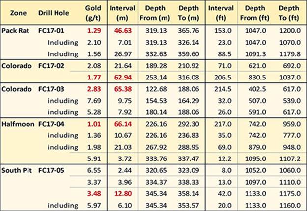
The drills confirmed a highly mineralized corridor between the Colorado and South Pit zones. Two holes targeting the Colorado zone returned lengthy intersections with decent grades – a respective 62.9 meters grading 1.77 g/t gold, and 65.4m at 2.83 g/t gold. The 65.4-meter intercept contained two higher-grade sections of drill core grading 7.69 g/t over 9.8m and 5.28 g/t over 7.9m. Getchell Gold states,
The 2017 drilling at Colorado supports the continuity and extent of the mineralization 250 metres (820 feet) down dip of where the zone is expressed at surface.
At Pack Rat, located about 400 meters southwest of Colorado, drill hole FC17-04 reported a 66.1 m intersection grading 1.01 g/t gold from 226.2 to 292.3m down hole, extending mineralization about 70 meters down dip from previous drilling. Hole FC17-01 extended the zone by 250m down dip. The hole ended in mineralization grading 1.29 g/t gold over 46.6m, and is open at depth.
The 400 meters between Colorado and Pack Rat is also open, and remains underexplored. Notice how close the drill hits are to surface at both zones, indicating this is the best location to build a starter pit.
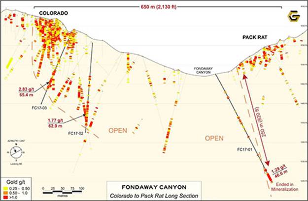
Fondaway Canyon Long Section, Colorado to Pack Rat Zone along 240° Az. looking SE
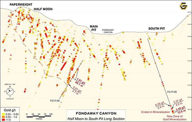
Over at Half Moon, drill hole FC17-04 extended the zone 70m down dip, with an intersection of 1.01 g/t gold over 66.1m. At the South Pit zone, where an extensional fault is considered one of the most promising structures on the property, the mineralization encountered at the bottom of hole FC17-05 suggests it continues at depth. From a 12.8m intercept graded at 3.48 g/t, the hole cut a higher-grade interval of 5.97 g/t gold over 6.1m.
Fondaway Canyon Long Section, Half Moon to South Pit Zone along 240° Az. looking SE
Fondaway Canyon Central Area – Select Highlights from the 2017 Drill Program
Conclusion
Fondaway Canyon has everything you’d want in a Nevada-style environment – 1.1Moz is a nice start. And while that would not be classified as a big Nevada deposit, Fondaway has all the characteristics of one. How do we know?
First, drilling into any one of the zones will almost certainly add ounces. For example very little exploration has been done on the 400-meter area between Colorado & Pack Rat. It seems a no-brainer to plant holes at 50-60m spacings within the upper stratigraphy. Pretty much everywhere holes have been drilled at surface on this property, they have hit mineralization.
Even the sparse, deep drilling has all holes hitting, so I envision GTCH building a whole pile of ounces there too. Adding ounces at existing zones will be hard work, but it will build the value and put ounces into the resource category.
Second, it is obvious there is a system wide open at depth with the potential to add ounces exponentially. An ideal place to start is the Halfmoon zone, where two prolific structures are crossing each other. It seems prudent to target a deep hole and follow the intersection of those two structures below surface.
The Colorado zone is also a good candidate to chase what could be a big gold system at depth. From a geological perspective I am extremely encouraged by Holes 2 and 3, as well as all the other holes along that structure, demonstrating it is even more robust as it carries to depth – 65m and 63m wide intercepts of 2 gram-plus material, and even higher grades, tells me that you need to drill deep. Getchell should be putting in a 600 – 1,000m hole into the bottom of this system to see if there is a pipeline of mineralization.
A third opportunity is the Pediment play which is definitely going to get some focus from Getchell’s management team. Two holes were drilled into the pediment, a distant 180m apart, but with clean, decisive intercepts on both holes.
The southerly hole returned 18m of 0.67g/t. The northerly hole is longer – 27m of 0.82g/t, including 12m of 1.35g/t – and doubled the grade. Imo, a 27-meter intercept is worth chasing on any property, let alone one with this much juice around it, and now you have a vector, a direction to chase mineralization to a potential source.
The more I learn about this project, the more it is beginning to look like a very large system. We started with 1.1Moz but the blue-sky potential is evident. I’m optimistic Getchell is, so far, just tickling the surface of a much bigger system.
The bottom line for me? Getchell Gold’s Fondaway Canyon has a large alteration footprint more characteristic of intrusives, ie., much bigger systems than what we are seeing with the emplacement of gold in veins.
Getchell Gold
CSE:GTCH
Cdn$0.25, 2020.05.12
Shares Outstanding 54,807,000m
Market cap Cdn$8.96m
GTCH website
Richard (Rick) Mills
subscribe to my free newsletter
aheadoftheherd.com
Ahead of the Herd Twitter
Legal Notice / Disclaimer
Ahead of the Herd newsletter, aheadoftheherd.com, hereafter known as AOTH.
Please read the entire Disclaimer carefully before you use this website or read the newsletter. If you do not agree to all the AOTH/Richard Mills Disclaimer, do not access/read this website/newsletter/article, or any of its pages. By reading/using this AOTH/Richard Mills website/newsletter/article, and whether or not you actually read this Disclaimer, you are deemed to have accepted it.
Any AOTH/Richard Mills document is not, and should not be, construed as an offer to sell or the solicitation of an offer to purchase or subscribe for any investment.
AOTH/Richard Mills has based this document on information obtained from sources he believes to be reliable but which has not been independently verified. AOTH/Richard Mills makes no guarantee, representation or warranty and accepts no responsibility or liability as to its accuracy or completeness. Expressions of opinion are those of AOTH/Richard Mills only and are subject to change without notice. AOTH/Richard Mills assumes no warranty, liability or guarantee for the current relevance, correctness or completeness of any information provided within this Report and will not be held liable for the consequence of reliance upon any opinion or statement contained herein or any omission. Furthermore, AOTH/Richard Mills assumes no liability for any direct or indirect loss or damage or, in particular, for lost profit, which you may incur as a result of the use and existence of the information provided within this AOTH/Richard Mills Report.
AOTH/Richard Mills is not a registered broker/financial advisor and does not hold any licenses. These are solely personal thoughts and opinions about finance and/or investments – no information posted on this site is to be considered investment advice or a recommendation to do anything involving finance or money aside from performing your own due diligence and consulting with your personal registered broker/financial advisor. You agree that by reading AOTH/Richard Mills articles, you are acting at your OWN RISK. In no event should AOTH/Richard Mills liable for any direct or indirect trading losses caused by any information contained in AOTH/Richard Mills articles. Information in AOTH/Richard Mills articles is not an offer to sell or a solicitation of an offer to buy any security. AOTH/Richard Mills is not suggesting the transacting of any financial instruments but does suggest consulting your own registered broker/financial advisor with regards to any such transactions.
Richard does not own shares of Getchell Gold (CSE:GTCH). However, GTCH is an advertiser on his site and is paid by GTCH to write articles on Getchell Gold. The Management and Board of Getchell Gold Corp. does not endorse this or any article, nor do they certify the accuracy of its contents.
Legal Notice / Disclaimer
Ahead of the Herd newsletter, aheadoftheherd.com, hereafter known as AOTH.Please read the entire Disclaimer carefully before you use this website or read the newsletter. If you do not agree to all the AOTH/Richard Mills Disclaimer, do not access/read this website/newsletter/article, or any of its pages. By reading/using this AOTH/Richard Mills website/newsletter/article, and whether you actually read this Disclaimer, you are deemed to have accepted it.
