Rest of Canada, parts of US sharing in BC’s wildfire misery – Richard Mills
2023.06.09
Fire season in British Columbia, it seems, is coming earlier every year.
A fortnight before the official start of summer, the growing wildfire count is fueling concerns about what will unfold in the weeks ahead.
Residents have already seen a number of hot, dry stretches elevating the risk, with another “mini-heat wave” enveloping the southern part of the province this week.
Global News said parts of the Interior such as Lytton could see temperatures surge to 37C on Wednesday, while areas like the Kootenays and Okanagan Valley could see highs of up to 35.
Campfire bans will be prohibited in many areas of BC as of noon Thursday, June 8th.
As of Wednesday, there were 81 active wildfires, the biggest being the Donnie Creek blaze near Fort St. John. Stretching for more than 2,400 square kilometers, it is the second largest forest fire in BC history.
Others include the Pigeon Creek wildfire burning east of Peachland, and the Cameron Bluffs fire west of Highway 4 near Cathedral Grove, about halfway between Parksville and Port Alberni on Vancouver Island.
The latter is significant as the area rarely gets forest fires, especially this early in the season. The Cameron Bluffs fire closed Highway 4 on Tuesday, stranding some travelers. The route is the only road connecting Port Alberni, Tofino and Uclulet to the rest of the Island. As of this writing, it remains closed.
Donnie Creek, Pigeon Creek, Cameron Bluffs, Peavine Creek and West Kiskatinaw River are all considered fires of note and out of control, according to the BC Wildfire Service.
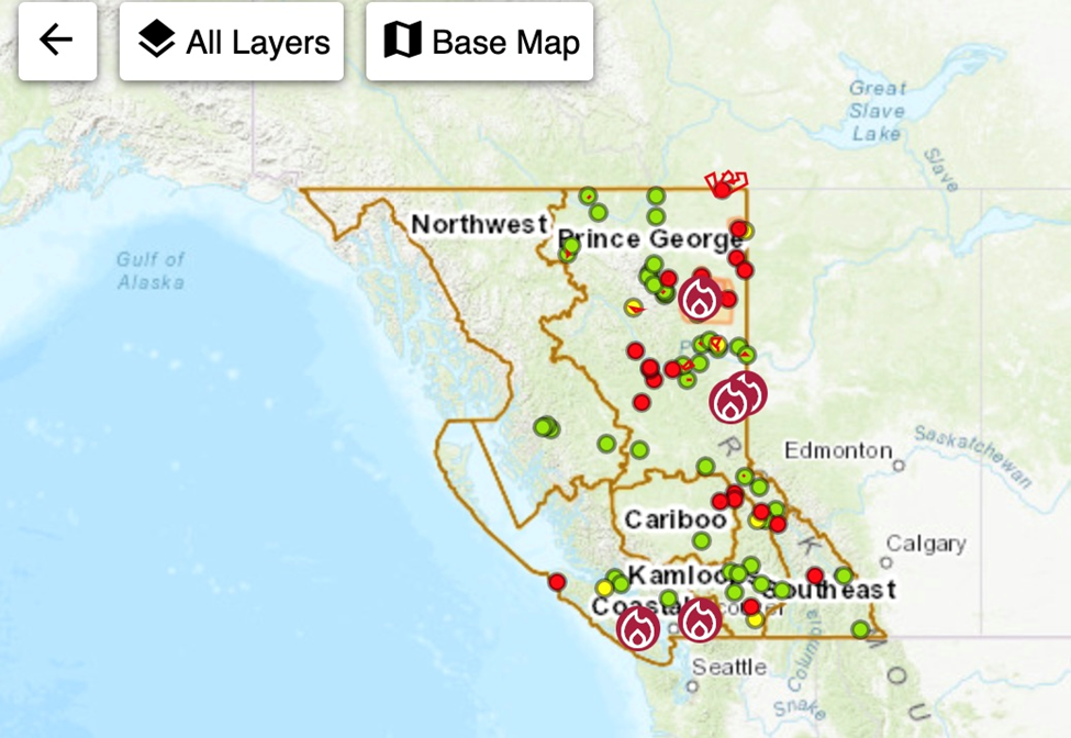
As always, rain is needed to keep the fires from spreading, but none is in the forecast. The BC Forest Service says this was the driest May on record for the coastal region, with the current fire danger rating at moderate to high with the exception of Haida Gwaii. “This means that we are seeing forest fuels drying and they will continue to dry until we see a significant amount of rainfall,” a spokesperson told Global.

Earlier we wrote about the intense wildfire situation in Alberta and northeastern BC, along with flooding in southern BC.
Western Canada had been enduring a cold spring, but the rapid onset of unseasonably high temperatures in places 10 to 15 degrees above average for early May, caused both fires and flooding.
According to the Alberta Wildfire Status Dashboard, there are currently 70 active fires in Alberta, including nine fires of note. The largest, the Rocky Creek fire, is about 7 km north of Fort Chipewyan. The out-of-control blaze has grown to 24,106 hectares, and presently has firefighters, helicopters and air tankers working on it.
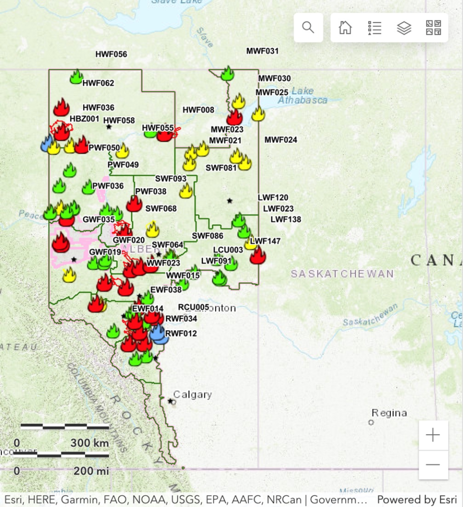
Forest fires in the Prairies aren’t as bad as in Alberta and BC, but there are still significant threats to property, along with the usual risk to respiratory health from wildfire smoke, which contains harmful fine particulate matter. According to the Saskatchewan Active Wildfire Situation Map, there are currently 28 active wildfires. The map below shows five of them are not contained.

As of Tuesday there were 14 active wildfires in Manitoba, with crews focused on three fires near Little Grand Rapids, Pauingassi and St. Theresa Point. In its latest fire bulletin, via Global News, the province says while the fire is several kilometers away from those areas, smoke may be an issue for communities.
There have been 70 wildfires so far in Manitoba this year.
Of course, forest fires in Western Canada are nothing new, but what is newsworthy this year, is how residents of other parts of the country not normally accustomed to fires, are finding themselves in the same predicament as Western Canadians — uncertain whether they will be in the path of rapidly moving fires usually pushed by the wind dangerously close to communities. Evacuation alerts, evacuation orders, the threat of property destruction, of wildfire smoke, and even the risk to human life, are all possibilities, especially for people living outside of big cities where forests often interface with homes and businesses.
In fact, the country is seeing its worst-ever start to the fire season, and is on track to experiencing the worst season for wildfires in history, if the rate of land burned continues at the same pace.
That, according to Reuters, is 3.8 million hectares, roughly 15 times greater than the 10-year average.
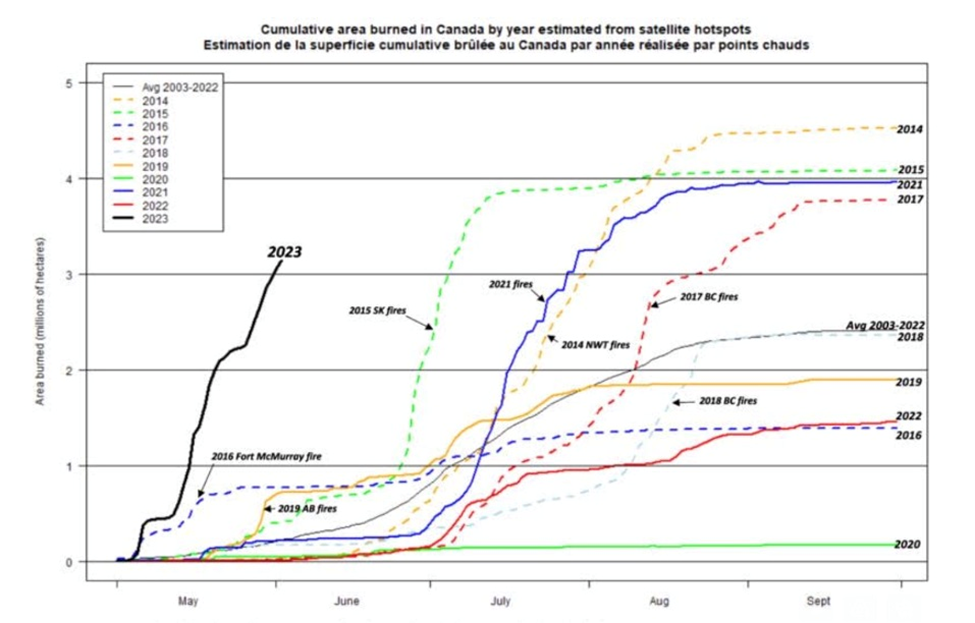
Canadian government officials say around 400 active fires are burning across the country, prompting 26,000 Canadians to evacuate their homes. The most out-of-control fires are in Quebec.
The officials blame climate change, including widespread heat and drought, for the increased frequency and intensity of wildfires. And it is only likely to get worse. The federal government is projecting the potential for higher-than-normal fire activity across most of the country through to August.
Already, Ottawa has approved requests for federal assistance from Quebec, Nova Scotia and Alberta, including calling in the army. Hundreds of personnel have also been sent from the US, Australia, New Zealand, South Africa and Costa Rica, Bloomberg reports.
A recent wildfire in Halifax forced more than 16,000 Nova Scotians to evacuate, while in Quebec, roughly 10,000 people had to leave their homes, mostly in the eastern Côte-Nord and western Abitibi regions.
Several mining companies throughout Eastern Canada have temporarily halted operations and exploration activities due to the fires. As reported by Bloomberg, they include:
- Iron Ore Co. of Canada, which idled operations at the mine, concentrator and pellet plant in Labrador City, Newfoundland;
- Hecla Mining, which suspended operations at its Casa Berardi gold mine located in the northern Abitibi region;
- Agnico Eagle Mines, which reduced operations at some of its sites between June 2 and June 5;
- Wallbridge Mines, which temporarily evacuated the camp at its Fenelon Gold project and suspended exploration activities; and
- Osisko Mining, which withdrew staff at its Windfall gold project.
Also affected were Resolute Forest Products, which halted one facility due to a logging ban. Francois Legault, the Quebec premier, reportedly voiced concerns about the threat to key electrical infrastructure owned by Hydro-Quebec in the Baie-Comeau area, where two water bombers were dispatched.
The issue is not just the fires, but the smoke, something Western Canadians have become all too familiar with.
“A thick haze hovered over Parliament Hill and the soaring Gothic Revival building that houses Canada’s Parliament in Ottawa. The sun was obscured by smoke, the sky an apocalyptic orange hue,” The New York Times described on Wednesday.
The hazy pall has settled over New York City and worsened air quality from Minnesota to Massachusetts. On Wednesday the big apple was second only to Delhi, India, for worst air quality, a rating given to Vancouver in 2020 due to fires that year.


Millions of Canadians too are breathing in smoke, with air quality levels in Ottawa and Toronto dangerously high, and officials advising people to stay indoors and to wear N95 masks when outside.
As for why the fires are happening at such an alarming frequency and across so much of Canada, the explanation comes down not only to climate change but to ongoing climate and weather patterns such as El Nino, and people being careless with cigarettes and camp fires.
Quebec’s multiple fires have been caused by lightning, whereas in Nova Scotia, they have primarily been human-caused. Nova Scotia has already had more fires in 2023, 168, than the 153 in all of 2022. Remember, the summer has not even officially started yet.
Making the Maritime province prone to fires this year was a low snowfall followed by an exceptionally dry spring; and Hurricane Fiona, which hit Atlantic Canada in September, 2022. The region has been hotter than usual and scientists expect temperatures to continue rising.
Regarding the dry spring, while the Maritimes are covered by Acadian forest, which contains broadleaf trees like sugar maples, that tend to be less flammable than evergreens (pine trees, firs, cedars, etc.), this year the leaves were unable to hold as much moisture.
Reuters reports Halifax received just 120 millimeters of rain between March and May, roughly a third of the average. Then, a late May heatwave pushed temperatures to 33 degrees Celsius, around 10 degrees above normal for this time of year.
As for Hurricane Fiona, there is speculation that trees felled during the storm, or killed by an infestation of pests, may be providing more fuel than usual for wildfires.
“Fires in areas where Hurricane Fiona downed trees have the potential to move faster and burn more intensely, making them potentially more difficult to contain and control. At this time, needles, twigs, leaves, etc., support fire ignition and spread,” the Department of Natural Resources and Renewables (DNRR) said in a statement.
Another theory is that Nova Scotia has been “emptying our urban area of wetlands,” The National Observer reports, which act as natural fire breaks.

El Niño
One of the most important predictors of weather are the climate patterns known as La Niña and El Niño.
It’s been well-established that warmer, or colder-than-average ocean temperatures have an influence on weather. To see how this works, watch a video or read the following by the National Oceanic and Atmospheric Administration (NOAA):
During El Niño, trade winds weaken. Warm water is pushed back east, toward the west coast of the Americas…
El Niño can affect our weather significantly. The warmer waters cause the Pacific jet stream to move south of its neutral position. With this shift, areas in the northern U.S. and Canada are dryer and warmer than usual. But in the U.S. Gulf Coast and Southeast, these periods are wetter than usual and have increased flooding…

El Niño causes the Pacific jet stream to move south and spread further east. During winter, this leads to wetter conditions than usual in the Southern U.S. and warmer and drier conditions in the North.
La Niña has the opposite effect of El Niño. During La Niña events, trade winds are even stronger than usual, pushing more warm water toward Asia…
These cold waters in the Pacific push the jet stream northward. This tends to lead to drought in the southern U.S. and heavy rains and flooding in the Pacific Northwest and Canada. During a La Niña year, winter temperatures are warmer than normal in the South and cooler than normal in the North. La Niña can also lead to a more severe hurricane season.
A May 3 update from the World Meteorological Association states that the likelihood of El Niño happening later this year is increasing. This would result in higher global temperatures.
According to the WMA report, an unusually stubborn three-year La Nina pattern has now ended, and we are currently in a neutral state, of neither El Niño nor La Niña.
Last time there was a strong El Niño summer, in 2015, every Canadian city had at least one month above normal. During the Fort McMurray fires, in 2016, El Niño was near the end of its sequence.

The latest information shows a continued high probability of El Niño establishing itself. Earlier this month, CTV News reported the United Nations’ weather agency saying that there is a two out of three chance of a worldwide temporary warming period (i.e., El Niño), beginning sometime over the next five years.
El Niño is shorter-lived than La Niña, usually lasting nine months to a year versus a few years for the cooling phenomenon.
The jet stream
Aside from El Niño and La Niña, weather in Canada is largely influenced by the jet stream, a narrow band of winds that swirl about 10 kilometers above the Earth. Because the winds are so strong, between 160 and 320 km/h, they push low- and high-pressure systems across the country, often dictating temperature and precipitation.
When El Niño is brought into the picture, it can strongly impact the jet stream, causing different weather patterns across Canada.
According to the National Oceanic and Atmospheric Association (NOAA), via CTV News, when the jet stream is under El Nino conditions, it makes northern areas like Canada dryer and warmer than usual.
Depending on the strength of the heat, some areas will receive more precipitation while others could face severe drought, the media outlet quoted Richard Dewey, associate director of science with Ocean Networks Canada.
That’s because when warmer air from El Niño presses into the country, it creates what is called an Omega blocking pattern in the jet stream.
“On the backside of an Omega blocking pattern, you have a big depression of the polar air, so cold air is much deeper south than normal,” Dewey said. “And sometimes these patterns just sit there for a long time.”
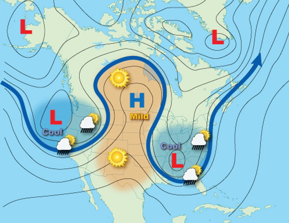
According to an article from NASA, at the time of the Fort McMurray fires in 2016, hot, dry weather was sitting over Alberta in the Omega blocking pattern.
Most forecasters believe if El Niño kicks in across the Pacific Ocean, Western Canada could be quite dry in coming months. According to North American Drought Monitor, at the end of April, 54.5% of the Great Plains was in moderate to exceptional drought, while 39.6% of the Columbia River Basin and 42.9% of the Rio Grande/ Bravo River Basin were in moderate to extreme drought.
In Canada, Drought Monitor says 34% of the country by April 30 was classified as abnormally dry, or in moderate to severe drought. Despite April precipitation, the majority of British Columbia as of May 1 remained in moderate drought, with a few small pockets of extreme drought (red on the map). At the end of April, 65% of the Prairie region (Alberta, Saskatchewan, Manitoba) was classified as abnormally dry or in moderate to severe drought.

Conclusion
Up to this year, forest fires with all their flaming ferocity and foul-smelling smoke, full of lung-destroying particulate matter, have been Western Canada’s dirty little secret.
You won’t find warnings in any tourist brochures, but wildfires in British Columbia have become such a regular occurrence that visitors would be wise to time their visits outside of the months when BC’s forests annually catch fire.
Problem is, it’s getting harder to pin those months down. Fire season in Western Canada is starting earlier than normal, and the fires are becoming more frequent and more intense, as the climate warms. Winters have become warmer and shorter, meaning less snowpack and runoff, although the freshet can do damage in the form of flooding if warming occurs quickly and too soon, like it did this year in BC. Not enough moisture and more frequent winter storms are creating too much tinder on forest floors, the perfect kindling for fires caused either by lightning or human stupidity.
This year is shaping up to be the worst fire season ever in Canada. In early June, we already have fires in BC, Alberta, Saskatchewan, Manitoba, Ontario, Quebec and Nova Scotia. There is little to no rain in the forecast and the Farmer’s Almanac says most of the country is in for a warmer-than-normal summer, which officially starts on June 21 and lasts until early, sometimes late September. Temperatures could rise above 32C and some regions could experience 40C, when humidity and heat indices (“feels like” temps) are factored in.
Fires and smoke don’t follow borders, so it was only a matter of time before the haze from forest fires in Eastern Canada drifted state-side. The smoke has traveled up to 1,000 kilometers and can be detected as far south as Raleigh, North Carolina and Nashville, Tennessee. Canada has a wildfire problem and our American neighbors, forced to either risk breathing in the smoke or don a mask (we know how many feel about that) are unimpressed. If there was any doubt of Canada’s culpability in climate change, these late-spring wildfires will surely dispel it.
Richard (Rick) Mills
aheadoftheherd.com
subscribe to my free newsletter
Legal Notice / Disclaimer
Ahead of the Herd newsletter, aheadoftheherd.com, hereafter known as AOTH.
Please read the entire Disclaimer carefully before you use this website or read the newsletter. If you do not agree to all the AOTH/Richard Mills Disclaimer, do not access/read this website/newsletter/article, or any of its pages. By reading/using this AOTH/Richard Mills website/newsletter/article, and whether you actually read this Disclaimer, you are deemed to have accepted it.
Any AOTH/Richard Mills document is not, and should not be, construed as an offer to sell or the solicitation of an offer to purchase or subscribe for any investment.
AOTH/Richard Mills has based this document on information obtained from sources he believes to be reliable, but which has not been independently verified.
AOTH/Richard Mills makes no guarantee, representation or warranty and accepts no responsibility or liability as to its accuracy or completeness.
Expressions of opinion are those of AOTH/Richard Mills only and are subject to change without notice.
AOTH/Richard Mills assumes no warranty, liability or guarantee for the current relevance, correctness or completeness of any information provided within this Report and will not be held liable for the consequence of reliance upon any opinion or statement contained herein or any omission.
Furthermore, AOTH/Richard Mills assumes no liability for any direct or indirect loss or damage for lost profit, which you may incur as a result of the use and existence of the information provided within this AOTH/Richard Mills Report.
You agree that by reading AOTH/Richard Mills articles, you are acting at your OWN RISK. In no event should AOTH/Richard Mills liable for any direct or indirect trading losses caused by any information contained in AOTH/Richard Mills articles. Information in AOTH/Richard Mills articles is not an offer to sell or a solicitation of an offer to buy any security. AOTH/Richard Mills is not suggesting the transacting of any financial instruments.
Our publications are not a recommendation to buy or sell a security – no information posted on this site is to be considered investment advice or a recommendation to do anything involving finance or money aside from performing your own due diligence and consulting with your personal registered broker/financial advisor.
AOTH/Richard Mills recommends that before investing in any securities, you consult with a professional financial planner or advisor, and that you should conduct a complete and independent investigation before investing in any security after prudent consideration of all pertinent risks. Ahead of the Herd is not a registered broker, dealer, analyst, or advisor. We hold no investment licenses and may not sell, offer to sell, or offer to buy any security.
Legal Notice / Disclaimer
Ahead of the Herd newsletter, aheadoftheherd.com, hereafter known as AOTH.Please read the entire Disclaimer carefully before you use this website or read the newsletter. If you do not agree to all the AOTH/Richard Mills Disclaimer, do not access/read this website/newsletter/article, or any of its pages. By reading/using this AOTH/Richard Mills website/newsletter/article, and whether you actually read this Disclaimer, you are deemed to have accepted it.


