BC bracing for more floods, brought on by late snowpack, heavy rains and sudden hot weather
2022.06.24
British Columbia is once again locked into a weather pattern seemingly dictated by climate change.
An unusually cold spring in the western-most Canadian province has amped up the flood risk mostly due to an above-average snowpack for this time of year — made worse by high rainfall forecast for parts of the province, followed by at least four days of hot weather.
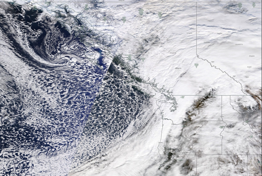
The impending natural disaster is the latest in a string of extreme weather events to hit the province. Last November, the BC government declared a state of emergency after an “atmospheric river” brought torrential rains to parts of southern BC and Washington State, causing severe flooding in the Fraser Valley, and washing away critical road & rail infrastructure. The widespread damage to farms, livestock, highways and bridges made it the costliest natural disaster in BC history. (The Insurance Bureau of Canada pegged the damage @ CAD$450 million, but this doesn’t include damage to infrastructure and other uninsured property, an amount that could reach upwards of $7.5 billion — Wikipedia)
Before the floods, the province was gripped by more than 1,600 wildfires that burnt nearly 8,700 square kilometers, making 2021 the third worst fire season on record. The season peaked far earlier than usual due to drought conditions brought on by a June “heat dome” that pushed temperatures above 40 degrees Celsius in some parts of the province. A Canadian heat record of 49 degrees C was set in Lytton; two days later, the southern BC village was consumed by wildfire, leaving two people dead and homes and businesses destroyed.
Normally about three-quarters of the snow in the alpine would be gone, but as of mid-June, only about half of the upper-elevation snowpack has melted, says Dave Campbell, head of the B.C. River Forecast Centre.
“We’re very much in the middle of the snowmelt [part] of the season. This is the time of the year [when] the province is exposed to increased risks, if that snowpack that is built up over the mountains melts off,” Campbell told The Weather Network, on Tuesday, June 21.
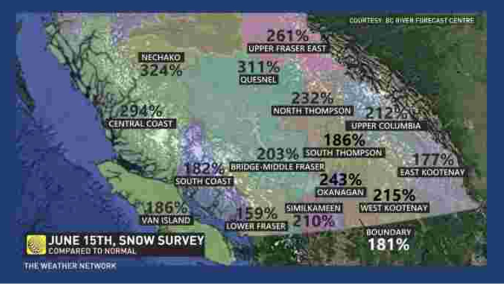
The freshet runoff into rivers and lakes has reached its height, but is expected to continue melting for the next two weeks.
Meanwhile, a low-pressure system is bringing heavy rain to parts of the province, prompting the River Forecast Centre to issue flood risk alerts for the Thompson River and Upper Columbia regions. Up to 40 mm of rain is anticipated for the South Thompson, Cariboo Mountains and Upper Columbia watersheds, adding to already “very high” river levels for this time of year, due to continued runoff and snowmelt.
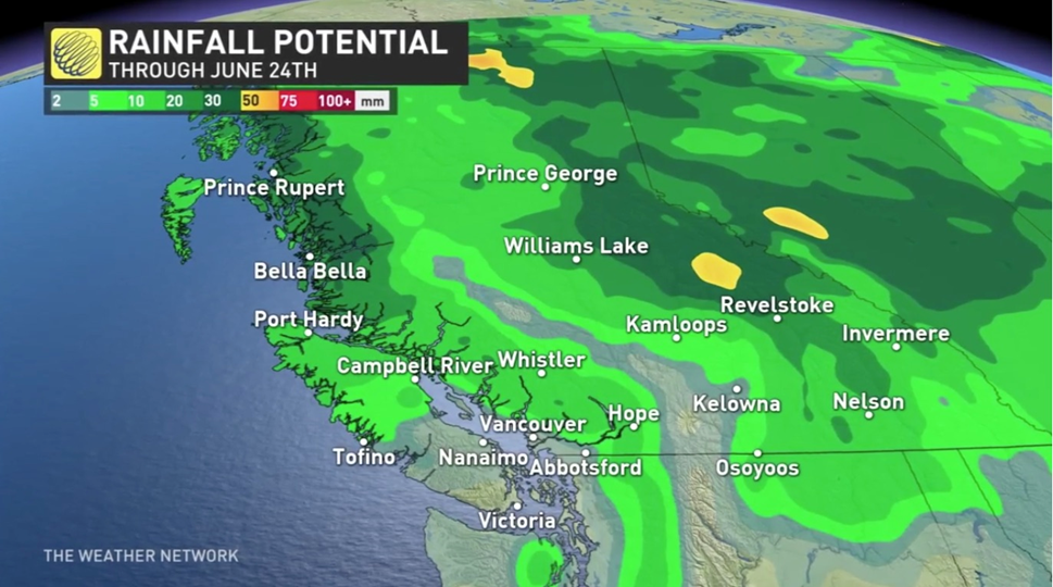
According to The Weather Network,
Flood watches are currently in effect for the central coast, Quesnel River, and the north and south Thompson rivers, as well as Liard River including tributaries around Fort Nelson and Highway 97 towards Watson Lake.
High streamflow advisories are in place for the Peace River basin, lower Fraser River, waterways in the northwest section of B.C., and eastern and western Kootenay.
Earlier this month, local states of emergency were declared in Kelowna and Sparwood because of isolated flooding occurring along Mission Creek, Scotty Creek, upper reaches of Mill Creek, officials said.
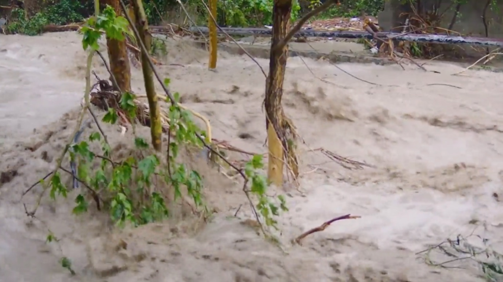
The City of Kamloops activated its Emergency Operation Centre as a precaution, and Kelowna remains under a State of Local Emergency enacted on June 14. The search for a missing local woman believed to have been swept away by Mission Creek while walking her dog, was paused Sunday due to poor weather conditions and exhaustion. The District of Sparwood extended its state of emergency until June 27.
According to EmergencyInfoBC, evacuation alerts are ongoing for areas west of Tulameen and in Harrison Mills west of Hope. A localized flooding alert has also been issued by the North Okanagan village of Lumby. The evacuation alerts affect the homes of about 580 people, meaning they may have to leave at a moment’s notice.
A flood warning is the most serious in a three-tiered alert system used by the River Forecast Centre and means flooding is expected. A flood watch means river levels are rising and flooding may occur.
The province is reportedly using B.C. Wildfire Service crews to help with sandbagging and flood mitigation in areas around the Fraser River, such as raising berms and dikes, and repairing critical infrastructure.
News-hour meteorologists have been warning for weeks that a sudden jag of hot weather would significantly increase the likelihood of flooding in BC, given that so much snow is still in the mountains.
The danger is that warmer temperatures will trigger rapid snowmelt and contribute to already high streams, rivers and lakes.
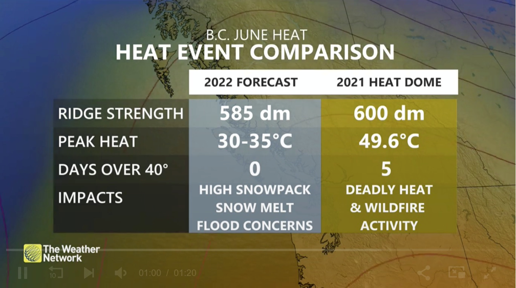
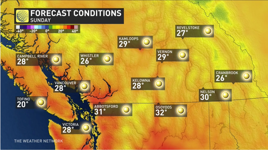
An offshore flow will allow temperatures to reach the mid-to-upper 20s along the South Coast, possibly reaching the 30-degree mark for downtown Vancouver, and into at least the low-to- mid-30s for some inland locations, including the Fraser and the Okanagan valleys…
The sudden uptick in temperatures could accelerate the snowmelt, which has been delayed, potentially leading to flooding in parts of the province, similar to what Kelowna saw this month. Numerous flood watches and high streamflow advisories are in place.
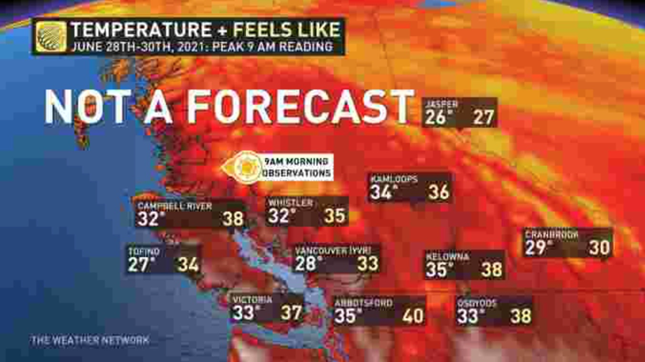
Meteorologists note, however, that the first heat wave of the summer will be nothing like the heat dome we experienced this time last year, which killed 619 people, mostly seniors lacking fans or air conditioning. Between June 28 and 30, 2021, 9 am readings showed temperatures across the province into the mid-30s, and even 40 in Abbotsford.
The forecast calls for cooler temperatures, in the upper 20s and low 30s, for the South Coast over the weekend and into early next week.
As for what can be done to lessen the scale of damage caused by warming-climate events such as flooding and wildfires, the provincial government recently released its climate adaptation strategy.
Four years in the making, the report promises half a billion dollars to protect communities from the same types of natural disasters that occurred in 2021, and are unfolding this week, i.e., floods and fires.
Among the climate resilience projects that BC will invest in, are floodplain mapping, wildfire prevention and extreme heat preparedness.
Most of the initiatives have already been announced, such as running BC’s wildfire service year-round, providing more staff and resources for the River Forecast Centre, and the province’s new extreme heat alert system, introduced earlier this month.
The strategy paper, via The Globe & Mail, says investments in adaptation including $221 million in this year’s budget, will save money in the long run. “Proactive investments can help us avoid higher costs and limit hardships associated with both climate-related disasters and slow-onset climate changes,” it reads.
Critics including the BC Green Party and West Coast Environmental Law, counter that the climate plan is only a fraction of what is needed, and that it lacks goals and timelines.
A 2020 study by the Insurance Bureau of Canada, cited by Andrew Gage, staff lawyer at West Coast Environmental Law, calculates that local governments nation-wide need to spend $5.3 billion a year to avoid the worst impacts of climate change.
The province points to scientific studies which concluded the extreme weather events of 2021, such as the atmospheric river and the heat dome, were made much more likely by global warming, and that such events will become more frequent as the climate continues to change.
Conclusion
Whether or not you believe global warming is human-caused or the result of the Earth’s natural warming and cooling cycles (we at AOTH lean towards the latter), there is no denying that climate change is happening all around us, and a lot quicker than most had expected.
Since the 1990s, the number of weather-related disasters around the world has doubled. Examples include forest fires, flooding, aquifer depletion, sea rise, saltwater intrusion, atmospheric rivers, heat domes, hurricanes, severe snow storms and deep freezes.
Scientists are warning that future temperature will test humas’ ability to survive, with some parts of the planet becoming uninhabitable. Our current heat measurements may be underestimating the dangers of extreme heat to the human body. Meteorologists are therefore turning to the “wet bulb globe temperature” for a more accurate reading.
It was previously thought that wet bulb temperatures very rarely exceeded 91 degrees F, but a 2020 study quoted by Popular Science found that this point has been crossed many times. Among the regions that have experienced this kind of extreme heat, are South Asia, the coastal Middle East, and coastal southwestern North America.
Droughts are impacting food production in Canada and the United States, lowering crop yields, and causing ranchers to cull part of their herds. Lake Mead, America’s largest manmade reservoir, and a source of water for millions, just fell to an unprecedented low.
The fresh water crisis has become so bad in California, that lawmakers want to buy up water rights’ from farmers to stave off drought.
A 2017 research paper found that each degree Celsius increase would on average reduce global yields of wheat by 6%, rice by 3.2%, maize by 7.4% and soybeans by 3.1%. These foods provide two-thirds of human caloric intake.
Although Western Canada has experienced an unusually cold and wet spring, there are indications we are in for another long, hot summer.
According to the Old Farmer’s Almanac, via CTV News, much of the country is in for a “sizzling summer” with “very warm, dry” conditions expected for parts of British Columbia.
This week’s torrential rain, cresting rivers and melting snowpack is likely just the beginning of another season of natural disasters in BC. If you live in a vulnerable area, best be prepared to leave in a hurry.
Richard (Rick) Mills
aheadoftheherd.com
subscribe to my free newsletter
Legal Notice / Disclaimer
Ahead of the Herd newsletter, aheadoftheherd.com, hereafter known as AOTH.
Please read the entire Disclaimer carefully before you use this website or read the newsletter. If you do not agree to all the AOTH/Richard Mills Disclaimer, do not access/read this website/newsletter/article, or any of its pages. By reading/using this AOTH/Richard Mills website/newsletter/article, and whether you actually read this Disclaimer, you are deemed to have accepted it.
Any AOTH/Richard Mills document is not, and should not be, construed as an offer to sell or the solicitation of an offer to purchase or subscribe for any investment.
AOTH/Richard Mills has based this document on information obtained from sources he believes to be reliable, but which has not been independently verified.
AOTH/Richard Mills makes no guarantee, representation or warranty and accepts no responsibility or liability as to its accuracy or completeness.
Expressions of opinion are those of AOTH/Richard Mills only and are subject to change without notice.
AOTH/Richard Mills assumes no warranty, liability or guarantee for the current relevance, correctness or completeness of any information provided within this Report and will not be held liable for the consequence of reliance upon any opinion or statement contained herein or any omission.
Furthermore, AOTH/Richard Mills assumes no liability for any direct or indirect loss or damage for lost profit, which you may incur as a result of the use and existence of the information provided within this AOTH/Richard Mills Report.
You agree that by reading AOTH/Richard Mills articles, you are acting at your OWN RISK. In no event should AOTH/Richard Mills liable for any direct or indirect trading losses caused by any information contained in AOTH/Richard Mills articles. Information in AOTH/Richard Mills articles is not an offer to sell or a solicitation of an offer to buy any security. AOTH/Richard Mills is not suggesting the transacting of any financial instruments.
Our publications are not a recommendation to buy or sell a security – no information posted on this site is to be considered investment advice or a recommendation to do anything involving finance or money aside from performing your own due diligence and consulting with your personal registered broker/financial advisor.
AOTH/Richard Mills recommends that before investing in any securities, you consult with a professional financial planner or advisor, and that you should conduct a complete and independent investigation before investing in any security after prudent consideration of all pertinent risks. Ahead of the Herd is not a registered broker, dealer, analyst, or advisor. We hold no investment licenses and may not sell, offer to sell, or offer to buy any security.
Legal Notice / Disclaimer
Ahead of the Herd newsletter, aheadoftheherd.com, hereafter known as AOTH.Please read the entire Disclaimer carefully before you use this website or read the newsletter. If you do not agree to all the AOTH/Richard Mills Disclaimer, do not access/read this website/newsletter/article, or any of its pages. By reading/using this AOTH/Richard Mills website/newsletter/article, and whether you actually read this Disclaimer, you are deemed to have accepted it.


